Chapter 4: Caring for the environment
Objectives:
- To ensure that the unique qualities of the city, its built heritage and the character of its urban areas are safeguarded for the future
- To protect important landscape and natural features of the environment, including the city's Green Belt setting
- To protect and enhance the nature conservation and biodiversity interest of the city
- To protect natural resources
Background
4.1 This chapter sets out a series of policies designed to ensure the protection of the different elements of the environment which have been identified as having special interest, value and importance. The policies deal with historic buildings and townscapes, parks, gardens and landscapes, monuments and archaeological remains which make up the historic environment. They deal also with the Edinburgh Green Belt, which has a role in protecting the city's landscape setting, and important elements of the natural heritage, including wildlife sites in the city and its surrounding countryside. Their importance ranges from the local to the international importance of the World Heritage Site and the Special Protection Areas in the Firth of Forth, towards which the Council has special responsibilities. Collectively, they create an environment of extraordinary richness and beauty. A key role for the Plan is to integrate conservation policies into the wider policy framework, and promote development which will care for the historic environment and the natural heritage, mitigate adverse impacts and contribute towards restoration and enhancement.
4.2 The Council plays an active role in the conservation, restoration and improvement of the built and natural heritage. It part funds Edinburgh World Heritage, Edinburgh and the Lothians Greenspace Trust and the Water of Leith Conservation Trust. It can initiate or participate in improvement schemes for local areas: it has set up the Leith Ahead initiative, drawing on lottery funding and aiming to deliver long-term benefits in the Leith Conservation Area. Portobello and the South Side Conservation Areas have benefited from 'townscheme' grants, in which Council funding for improvements is matched by Historic Scotland. Voluntary groups of residents and interested people have played and continue to play a major role in conservation activity, for example, in preparing character appraisals for conservation areas and in preparing and implementing the Edinburgh Biodiversity Action Plan.
Environmental Assessment
4.3 Planning authorities have wide ranging obligations and powers to collect and evaluate environmental information from applicants before deciding whether or not to grant planning permission and under what conditions. This may involve consultation with statutory bodies such as SEPA (the Scottish Environment Protection Agency), Historic Scotland and SNH (Scottish Natural Heritage). The planning system therefore provides a means for assessing the environmental effects of all applications before decisions are made, and ensuring that appropriate mitigation is put in place. For certain types of application specified in regulations a comprehensive evaluation of environmental effects in the form of an Environmental Impact Assessment is required. The Council may also ask that an Environmental Impact Assessment is prepared for other applications judged likely to have significant environmental effects. Major proposals within or affecting the World Heritage Site are likely to fall within this category.
The Historic Environment
The World Heritage Site
Policy Env 1 World Heritage Site
Development which would harm the qualities which justified the inscription of the Old and New Towns of Edinburgh as a World Heritage Site or would have a detrimental impact on the Site's setting will not be permitted.
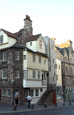
4.4 World Heritage Sites are places of outstanding universal value, recognised as such under the terms of the 1972 UNESCO Convention concerning the Protection of the World Cultural and Natural Heritage. Outstanding universal value is defined by UNESCO as cultural and/or natural significance which is so exceptional as to transcend national boundaries. Member states are encouraged to nominate sites for inscription and ensure that they have the necessary level of protection. The 'Old and New Towns of Edinburgh World Heritage Site' was accepted on the list of World Heritage Sites in 1995. The boundaries are shown on the Proposals Map; these cover all or part of seven conservation areas, reflecting the complexity of the Site.
4.5 Designation does not confer any additional statutory powers: protection is achieved primarily through the effective operation of the planning system and controls derived from other primary legislation, including listed building and conservation area legislation. The outstanding value of the Edinburgh Site as agreed at inscription, including its authenticity and integrity, is a key material consideration when decisions are taken on applications for planning permission and other relevant applications, whether by the Council or Scottish Ministers. The Site is unusual in a Scottish context in being a central urban area, resulting in greater pressures for change, which must be accommodated sensitively and harmoniously. Development proposals affecting the Site including its setting will come under close scrutiny, usually by means of formal environmental assessments and design statements, to ensure that immediate and long-term impacts are fully evaluated and will be compatible with World Heritage status and objectives. Setting may include sites in the immediate vicinity, viewpoints identified in the key views study and prominent landscape features throughout the city.
4.6 Historic Scotland and the Council have jointly set up the Edinburgh World Heritage Trust to assist with the management of the Site. The Trust has responsibility for grant aid disbursement, site promotion and preparation of the necessary management plan; this draws together all the relevant issues, some of which do not relate to planning, and reflects advice given in UNESCO's Operational Guidelines for the Implementation of the World Heritage Convention. The management plan may itself be a material consideration for decisions on planning matters. Historic Scotland has issued a Statement of Significance to assist with a shared understanding of the value of the site.
Figure 4.1 World Heritage Site
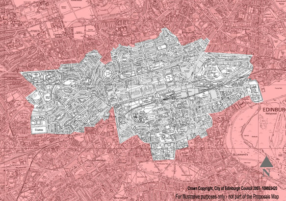
View larger World Heritage Site map (jpeg, 510kb)
Listed Buildings
Policy Env 2 Listed Buildings - Demolition
Proposals for the total or substantial demolition of a listed building will only be supported in exceptional circumstances, taking into account:
- the condition of the building and the cost of repairing and maintaining it in relation to its importance and to the value to be derived from its continued use
- the adequacy of efforts to retain the building in, or adapt it to, a use that will safeguard its future, including its marketing at a price reflecting its location and condition to potential restoring purchasers for a reasonable period.
- the merits of alternative proposals for the site and whether the public benefits to be derived from allowing demolition outweigh the loss.
Policy Env 3 - Listed Buildings - Setting
Development within the curtilage or affecting the setting of a listed building will be permitted only if not detrimental to the appearance or character of the building, or to its setting.
Policy Env 4 - Listed Buildings - Alterations and Extensions
Proposals to alter or extend a listed building will be permitted where those alterations or extensions are justified, will not cause any unnecessary damage to historic structures or diminish its interest and where any additions are in keeping with other parts of the building.
4.7 The Statutory List of Buildings of Special Architectural or Historic Interest identifies around 4,500 items (31,500 buildings) for Edinburgh. Where the Council considers that an unlisted building merits special protection, it can ask for the building to be considered for listing, or in urgent cases serve a Building Preservation Notice.
4.8 In determining applications for planning permission or listed building consent the Council is required to have special regard to the desirability of preserving the building, or its setting or any features of special interest that it possesses. Applications for the demolition or substantial alteration of a listed building must be accompanied by a thorough structural condition report demonstrating that the proposals are necessary or justified, and in the case of demolition proposals, that every possibility of retaining the building in an alternative viable use has been explored, including its sale on the open market. Proposals for the replacement building will also need to be before the Council; these should be of comparable quality in terms of construction and design.
4.9 Edinburgh does not have a legacy of derelict listed buildings, and only a small number are on the Scottish Civic Trust’s Buildings at Risk Register, which could justify intervention to safeguard their future. Instead, the record is of the large number of listed buildings which have been given new leases of life by sensitive restoration and adaptation to new uses if necessary. The loss of a listed building will only seldom be justified.
Conservation Areas
Policy Env 5 - Conservation Areas - Demolition of Buildings
Proposals for the demolition of an unlisted building within a conservation area but which is considered to make a positive contribution to the character of the area will only be permitted in exceptional circumstances and after taking into account the considerations set out in Policy Env 2 above.
Proposals for the demolition of any building within a conservation area, whether listed or not, will not normally be permitted unless a detailed planning application is submitted for a replacement building which enhances or preserves the character of the area or, if acceptable, for the landscaping of the site. Conservation Area Consent will be subject to conditions or legal agreement to ensure that demolition does not begin until evidence has been given that contracts have been let for the approved replacement development.
Policy Env 6 - Conservation Areas - Development
Development within a conservation area will be permitted which:
- preserves or enhances the special character or appearance of the conservation area and is consistent with the relevant conservation area character appraisal
- preserves trees, hedges, boundary walls, railings, paving and other features which contribute positively to the character of the area and
- demonstrates high standards of design and utilises materials appropriate to the historic environment.
Planning applications should be submitted in a sufficiently detailed form for the visual effect of the development proposal on the character of the area to be assessed.
4.10 Conservation Areas are areas which the Council has determined are of special architectural or historic interest, the character or appearance of which it is desirable to conserve or enhance. The main implication of designation is that consent is required for specific types of development that would not otherwise require it, for example, the demolition of unlisted buildings and work on trees not already covered by a Tree Preservation Order. In Edinburgh, this level of control has been further extended, with Scottish Executive approval, through the introduction of Article 4 Directions in all conservation areas. This enables the Council to control window alterations for example, and other alterations to individual dwelling houses which would not otherwise require to be the subject of planning applications.
4.11 The Proposals Map shows which parts of the city are covered by designated conservation areas. The boundaries of the 39 individual designated conservation areas are shown in Appendix A. All have been reviewed and either confirmed or modified since initial designation. A character appraisal has been completed for each conservation area identifying key characteristics which must be respected and there is supplementary planning guidance related to various topics which will be applied as appropriate. These are material considerations in the consideration of planning applications. When development of a site in a conservation area is proposed, the design statement required by Policy Des 1 should include a reference to the relevant appraisal and supplementary guidance, and show how this has informed the design. Appendix A also shows the boundary of a new conservation area which the Council intends to designate in 2010.
Historic Gardens and Designed Landscapes
Policy Env 7 - Historic Gardens and Designed Landscapes
Development will not be permitted which would have a detrimental impact on the character of a site recorded in the Inventory of Gardens and Designed Landscapes, upon important views to, from and within the site, or upon component features which contribute to its value. The restoration of Inventory sites will be encouraged.
4.12 Historic Scotland and Scottish Natural Heritage are jointly responsible for compiling and maintaining the national Inventory of Gardens and Designed Landscapes. The effect a development may have on an Inventory site is a material consideration for planning, and Councils are required to consult Historic Scotland on proposals affecting a site. Edinburgh’s Inventory sites are identified on the Proposals Map. This covers the policies of some country estates, designed and ornamental landscapes in the urban area, private gardens of varying size and cemeteries. The Inventory covers also parks and gardens of importance as part of the historical design and character of the New Town. The Council will protect sites on the Inventory from damaging development, and consider whether restoration or improvement can be achieved when considering development proposals. The Inventory is not exhaustive, and the Council will consider whether further designations are merited. Even for sites which are not included in the inventory, an understanding of how the landscape has evolved can help inform a development proposal and be a source of distinctiveness.
Scheduled Ancient Monuments and Archaeology
Policy Env 8 - Protection of Important Remains
Development will not be permitted which would:
- adversely affect a Scheduled Ancient Monument or other nationally important archaeological remains, or the integrity of their settings
- damage or destroy archaeological remains of more local significance which the Council considers should be preserved in situ.
Policy Env 9 - Development of Sites of Archaeological Significance
Planning permission will be granted for development on sites of known or suspected archaeological significance if it can be concluded from information derived from a desk-based assessment and ‘walk-over’ survey and, if requested by the Council, a field evaluation, that either:
- no archaeological remains are likely to be affected by the development
- any archaeological remains will be preserved in situ and, if necessary, in an appropriate setting
- the benefits of allowing the proposed development outweigh the importance of preserving the remains in situ. The applicant will then be required to make provision for archaeological excavation, recording, and analysis, and publication of the results before development starts, all to be in accordance with a programme of works agreed with the Council.
4.13 The Ancient Monuments and Archaeological Areas Act 1979 (pdf,4.5MB) protects many nationally important archaeological sites and monuments. In addition, there are many sites and monuments which, while not fulfilling the criteria for national importance, are of more local significance. All are fragile and vulnerable to damage or destruction. They contain information about the past, and the potential to increase knowledge in the future, and care must be taken to ensure that they are not needlessly destroyed. It may also be important to safeguard the integrity of the setting of an archaeological site. Preservation in situ is always the preferred option for all sites of known or suspected archaeological significance.
4.14 Edinburgh contains a wealth of archaeological sites and monuments. There are currently 30 ancient monuments in the schedule compiled by Historic Scotland. In addition, there is a substantial number of individual records within the Sites and Monuments Record which the Council maintains for its area. These cover all aspects and periods of archaeological resources both above and below the ground, including: prehistoric settlement and religious sites, Roman fortifications, medieval and later building and settlement remains, designed gardens and historic landscapes, cemeteries, battlefield sites and maritime sites. Using this record, the Council is able to advise prospective developers where there is a possibility or likelihood that remains exist, and early consultation with the Council is of crucial importance.
4.15 Where the Council knows or has reason to believe that important remains exist, an applicant will be required to carry out an archaeological evaluation and submit the findings with the planning application. Where important remains would be adversely affected by a proposed development, the Council may refuse planning permission or it may ask for the proposal to be modified to avoid their disturbance. Where preservation in situ is not necessary for acceptable planning reasons, the Council may agree to an archaeological excavation. If remains are of a minor or uncertain nature, the Council may allow the development to proceed subject to the condition that its archaeologist or another appropriate body is given reasonable access to the site, to hold a watching brief and investigate and record any remains which are found.
Countryside and Natural Heritage
The Edinburgh Green Belt
Policy Env 10 - Green Belt
Within the Green Belt as shown on the Proposals Map development will only be permitted:
- where necessary for the purposes of agriculture, woodland and forestry, horticulture or for a countryside recreational use compatible with an agricultural or natural setting, and provided also that any necessary buildings, structures or hard standing areas are ancillary to the main use, small scale and of high design quality
- where the proposal is for the change of use or small scale extension of an existing building, particularly a building of architectural or historic merit, provided that any proposed extension or ancillary development would not be detrimental to the character or appearance of the Green Belt
- where related to an existing non-conforming use or building in the Green Belt and provided the proposal is appropriate in type, scale and design to the existing building and not detrimental to the character or appearance of the Green Belt.
4.16 A Green Belt around Edinburgh was first established in 1957, and although there have been several reviews and boundary changes to accommodate necessary development, it has been an important tool in helping to shape Edinburgh’s growth and containment and support regeneration. It helps ensure that for the most part there is a strong and well-defined transition between the urban area and the countryside, and that the City Bypass road has for most of its length a rural setting. Scottish Government guidance through Scottish Planning Policy (SPP) 21 states that the key objectives of green belt policy are:
- to direct planned growth to the most appropriate locations and support regeneration
- to protect and enhance the character, landscape setting and identity of towns and cities and
- to protect and give access to open space within and around towns and cities, as part of the wider structure of green space.
4.17 In accordance with SPP21, Policy Env 10 above identifies the limited range of uses and developments that will be permitted in the Green Belt in the interest of preserving its predominantly open and rural character. Particular care will be taken to ensure that any ancillary developments such as car parking provision, lighting or areas of hard standing are not intrusive. The Council is concerned to see the Green Belt managed effectively in ways which will promote greater recreational use and access to the countryside, and will enhance its amenity and biodiversity value. Acceptable recreational uses in the Green Belt could include golf courses, parks and playing fields if appropriately laid out and landscaped, but uses which would prevent the quiet enjoyment of the countryside by others would not be acceptable.
4.18 SPP 21 does represent a shift in emphasis in green belt policy at the national level. Government guidance now places great emphasis on the need for the green belt boundary to reflect a long-term development strategy, and ensure that settlements are able to accommodate planned long-term growth. It therefore advises that inner boundaries should not be drawn too tightly around the urban edge. They should create an area suitable to accommodate planned growth over a 20-year period at least, obviating the need to encroach on green belt land in that period. SPP 21 also provides for the explicit exclusion from green belt designations of existing settlements, major educational and research uses, major business and industrial operations and airports, to allow for growth and change. All other uses should be retained in a green belt designation to afford a greater level of control over new development. A review of the Edinburgh Green Belt is underway to meet the objectives of SPP 21 and as part of the process of preparing the next strategic development plan.
4.19 Positive management of green belts is important, and the Council with the other Green Belt authorities has set up the Edinburgh and Lothians Greenspace Trust to work with land owners and initiate planting and other works that will enhance its appearance and amenity value. Most farmland in the Plan area has high productive capability and is graded ‘prime quality’. Prime farmland is a resource which according to current government policy should be protected from irreversible development. Proposals for sites of two hectares or more and which could affect the productive capability of prime quality farmland will be referred to the Scottish Government for advice.
Scenic Areas
Policy Env 11 - Landscape Quality
Planning permission will not be granted for development which would damage or detract from the overall character and appearance of the Areas of Great Landscape Value shown on the Proposals Map, prominent ridges, or other important topographical or landscape features.
4.20 Many of the most striking landforms in the urban area are not built over, but are preserved as parkland and woodland. The Pentland Hills meet the urban edge in the south west of the city and provide the backdrop to many of its finest views. These visually important areas of scenic interest are designated Areas of Great Landscape Value on the Proposals Map. This is not a statutory designation, but a designation which local planning authorities may use for the purpose of safeguarding locally important areas of outstanding scenic quality and character from inappropriate development. There are other open areas within the built up area the attractiveness and interest of which is enhanced by their scenic qualities. Development if acceptable will need to recognise the valuable contribution these make to the overall character and attractiveness of the city and should not diminish their significance. An appraisal of Edinburgh landscapes is underway, in accordance with the guidance issued by Scottish Natural Heritage, to confirm which areas merit special recognition or protection. These areas will be termed Special Landscape Areas (SLAs) and given individual names. The SLAs will replace the existing Area of Great Landscape Value designation. That reappraisal of Edinburgh's landscapes will inform the next review of the development plan and be incorporated in the Local Development Plan.
Protection of Trees
Policy Env 12 - Trees
Development will not be permitted if likely to have a damaging impact on a tree or trees protected by a Tree Preservation Order or other trees worthy of retention on or around a proposed development site, unless necessary for good arboricultural reasons. Where such consent is granted, replacement planting will be required to offset the loss to amenity.
4.21 The Council has placed Tree Preservation Orders on a large number of trees where they make a positive contribution to the character of the urban or rural environment, particularly where trees are threatened by development proposals. Trees can also be protected if they are within a conservation area. Not all trees or groups of trees worthy of protection are covered by Tree Preservation Orders. In assessing proposals affecting trees, the Council will consider their value, and decide whether they are important in their particular context. It will take into account their status, for example, whether they have been classified as ‘heritage trees’, Ancient Woodland or Millennium Woodland. Where they are, they will have to be protected both in the layout design and during the construction period. Developers may be required to carry out tree surveys of development sites at an early stage to ensure that trees worthy of retention are identified and taken into account in the layout design. The Council will continue to implement a programme of tree planting in the city, in accordance with its Urban Forestry Strategy, private woodland management schemes, the Lothians Forest Habitat Network and the Forestry Commission’s area of interest.
Nature Conservation
4.22 Planning has a major role in maintaining biodiversity generally and protecting important features of the natural environment in particular. Sites which are key elements of Scotland’s natural heritage are protected by national and international statutory designations. Additional non-statutory designations are employed by local authorities to give protection to sites of local importance for their wildlife and/or geological interest. These are of more value where they form part of a wider, connected habitat network. The following policies reflect this three tier order of importance, and also the Council’s obligations to take account of the impact of development on species protected by legislation and international commitments. Biodiversity encompasses the commonplace as well as the rare and may be a relevant consideration for development wherever it occurs. The Nature Conservation Scotland Act 2004 places a duty on all public bodies to further the conservation of biodiversity as far as is consistent with their functions. In accordance with this ‘biodiversity duty’ and Policy Des 3 above, developers will be encouraged to be positive and creative in addressing natural heritage issues. The Edinburgh Biodiversity Action Plan Plan has been prepared by the Edinburgh Biodiversity Partnership for the Council area, to provide a focus for action in conserving nationally and locally important species and habitats.
Policy Env 13 - Sites of European Importance
Development likely to have a significant effect on the Firth of Forth, the Forth Islands or the Imperial Dock Lock Special Protection Areas will be subject to an appropriate assessment, and will be permitted only if either:
- the assessment has concluded that the development will not adversely affect the integrity of the area or
- the assessment has not so concluded, but it has been demonstrated that:
- there are no alternative solutions and
- there are imperative reasons of overriding public interest for permitting the development, including reasons of a social or economic nature.
4.23 The Plan area covers one site, Imperial Dock Lock, classified as a Special Protection Area under the Wild Birds Directive, and parts of two others, the Forth Islands and the Firth of Forth. Special Protection Areas are part of a European Community-wide network of protected areas, the Natura 2000 network, designed to maintain or restore the abundance of species and habitats. Regulations relevant to these designations require that where the Council concludes that a development proposal is likely to have a significant effect on a Natura 2000 site, it must undertake an appropriate assessment of the implications for the conservation interests for which the area has been designated.
4.24 Developments must therefore pass the most stringent tests to be considered favourably. Where the importance of a development is judged to outweigh the nature conservation importance of a site, compensatory habitat measures will need to be taken to maintain the coherence of the Natural 2000 network.
Policy Env 14 - Sites of National Importance
Development which would affect a Site of Special Scientific Interest (other than a European Site) will only be permitted where an appraisal has demonstrated that:
- the objectives of the designation and the overall integrity of the area will not be compromised or
- any significant adverse effects on the qualities for which the area has been designated are clearly outweighed by social or economic benefits of national importance.
4.25 Sites of Special Scientific Interest (SSSIs) are areas of land (including land covered by water) which are considered by Scottish Natural Heritage to be of special interest by reason of their natural features, i.e. their flora, fauna or geological or geomorphological features. They are therefore sites of national importance, but SSSI designation may also underpin international designations such as SPAs and other sites in the Natura 2000 network. The Firth of Forth and Forth Islands SPAs are also SSSIs, and therefore the more stringent requirements of Policy Env 13 above will apply to developments affecting these. Development in or reasonably assumed likely to have an effect on an SSSI will be required to demonstrate the reasons which clearly outweigh the nature conservation interest of the site and justify a departure from the national policy to protect such sites. Scottish Natural Heritage will be consulted over any proposals, and any consent granted is likely to be subject to conditions or legal agreements by which the Council will seek appropriate mitigation or compensation measures.
Policy Env 15 - Sites of Local Importance
Development likely to have an adverse impact on the flora, fauna, landscape or geological features of a Local Nature Reserve or a Local Nature Conservation Site will not be permitted unless it can be demonstrated that:
- the reasons for allowing the development are sufficient to outweigh the nature conservation interest of the site
- the adverse consequences of allowing the development for the value of the site have been minimised and mitigated in an acceptable manner.
4.26 Planning authorities are encouraged to identify the additional sites with a nature conservation value that should be taken into account when development on or near these is proposed. In parallel with national designations, these may be of biodiversity interest (e.g. wooded areas, Ancient Woodlands, ponds, water courses or railway embankments which act as wildlife corridors through the urban area) or geodiversity interest (e.g. quarry faces, exposed rock features, interesting land forms) or both. A network of such sites has been identified and protected over several years and is shown on the Proposals Map (details in Appendix B). Candidate sites are assessed by the Edinburgh Biodiversity Partnership primarily on the basis of biological considerations: species richness and rarity and habitat rarity, naturalness and connectivity. Some regard is additionally had to social factors: the enjoyment derived locally from a site, its value for education and community involvement and its contribution to landscape quality. Sites are monitored and the list reviewed from time to time, in step with local plan preparation. Relatively extended corridor features such as railway embankments, rivers and unbuilt river banks have a special value in providing continuity of habitat in a built up area and this is recognised in some of the designations. Planning permission should only be granted for development in or affecting a site of nature conservation interest designated by the Council if other material factors are sufficient to override nature conservation considerations and/or if conditions can be imposed to prevent or offset damaging impacts.
4.27 In addition to these, planning authorities may designate Local Nature Reserves under the National Parks and Access to the Countryside Act 1949. Designated reserves in Edinburgh are shown on the Proposals Map. These are designated where community involvement in their running can be secured. They are actively managed in ways which protect their value for wildlife and promote their educational value and their enjoyment by the public.
Policy Env 16 - Species Protection
Planning permission will not be granted for development that would have an adverse impact on species protected under European or UK law, unless:
- there is an overriding public interest need for the development and it is demonstrated that there is no alternative
- a full survey has been carried out of the current status of the species and its use of the site
- any necessary licence has been obtained
- suitable mitigation is proposed.
4.28 As well as the requirements to protect important sites, it is necessary to be aware that some species of plants and animals have statutory protection through various European directives and UK laws, notably, the Habitats Regulations, the Protection of Badgers Act 1992, the Wildlife and Countryside Act 1981 (as amended) and the Nature Conservation (Scotland) Act 2004.
4.29 For proposals that could affect a European Protected Species the applicant will be required to submit information on the status of the species and its use of the site before the planning application can be determined. Species which may be encountered in Edinburgh include Bats, Great Crested Newts and Otters. Only imperative reasons of public interest will be sufficient to override the presumption against development. Proposals to mitigate the negative impacts of the development proposal on a European Protected Species will be required. These should ensure that the population concerned can be maintained at a favourable conservation status within its natural range. In some cases and for some purposes, a licence is needed, and must form part of the information submitted with a planning application before a decision can be reached.
Protection of Natural Resources
Flood Protection
Policy Env 17 - Flood Protection
Planning permission will not be granted for development that would:
- increase a flood risk or be at risk of flooding itself
- impede the flow of flood water or deprive a river system of flood water storage within the areas shown on the Proposals Map as areas of importance for flood management
- be prejudicial to existing or planned flood defence systems.
4.30 The water environment is a key natural resource which requires stringent protection from the potentially harmful effects of new development, both on water quality and in adding to flood risk. Within the urban area some built and some unbuilt areas have experienced flooding in extreme weather conditions. The Council has prepared and is implementing flood prevention schemes for the Water of Leith (river) and the Braid Burn. It has also identified unbuilt areas of land which fulfil an important flood function, and which should be allowed to flood in order to protect other, built-up areas from floodwater. These are shown on the Proposals Map as areas of importance for flood management. It is essential to maintain strict control over development in these areas. Proposals will only be favourably considered if accompanied by a flood risk assessment demonstrating how adequate compensating measures are to be carried out, both on and off the site. It should be noted however that in particular circumstances sustainable flood management or mitigation measures may not be achievable.
4.31 There are several stretches of culverted water courses in the city. Culverting can exacerbate flood risk and have a detrimental effect on biodiversity. Any further culverting would be opposed, and the removal of existing culverts will be sought when possible. As part of the planned urban expansion proposals at Greendykes, the Council has prepared proposals for the removal of culverts and the formation of a new channel for the Niddrie Burn (see Proposal OSR 6). This will provide a major new amenity for the area, and is part of proposals to remove the flood risk from areas which will be developed with housing.
4.32 An indicative flood map published by the Scottish Environment Protection Agency shows some areas on Edinburgh's waterfront potentially at medium to high risk of coastal flooding, taking into account climate change. Development in such areas may still be acceptable provided that the risk has been assessed and adequately addressed, for example through raised levels or improved coastal defences.
4.33 New development generally has the potential to add to flood risk if it leads to an increase in surface water run-off. Policy Des 6 in the Design chapter states that this should be avoided by the use of sustainable drainage techniques (SUDs). This is a comprehensive design approach to the management of water on a site, to delay run-off and encourage filtration through the use of porous surfaces, detention ponds, etc. in ways which enhance amenity and biodiversity and minimise pollution effects.
Pollution and Air, Water and Soil Quality
Policy Env 18 - Air, Water and Soil Quality
Planning permission will only be granted for development where:
- there will be no significant adverse effects for health, the environment and amenity and either
- there will be no significant adverse effects on air, water or soil quality
- appropriate mitigation to minimise any adverse effects can be provided.
4.34 Pollution can arise from many sources and activities: traffic and transport, industrial processes, agriculture, waste disposal and landfill. Air, soil and water quality can all be affected and harmed by some forms of development. Land can present a potential pollution threat if it has been contaminated by previous activities. Air, noise and light pollution can also be a source of harm to health and amenity. The potential risk and significance of pollution will be considered when assessing planning applications, in consultation where necessary with relevant agencies, notably Scottish Environment Protection Agency and the Health and Safety Executive.
4.35 The planning system has a role to play in the protection of air quality, by ensuring that development does not adversely affect air quality in any Air Quality Management Area that has been declared. These are areas where air quality standards are not being met, and for which remedial measures should therefore be taken. AQMAs have been declared for three areas of the city, one covering much of the city centre, one covering parts of Corstorphine around St. John's Road and a third covering Great Junction Street in Leith. Poor air quality in these locations is largely due to traffic congestion. The Council has prepared an action plan setting out measures intended to help reduce vehicle emissions within these areas.