Chapter 11: Waterfront Regeneration
Objective:
- To ensure that the areas of major change along the waterfront are developed in the most appropriate way within the context of a long-term vision
Priorities
11.1 The decline of port related and industrial activity in waterfront areas and the reduced need for industrial land generally in north Edinburgh has given the city a unique opportunity, a step change above others in the city, to meet its growth needs and set new standards of urban design and sustainability. The sites are among the most significant in Scotland, comparable with other major waterfront sites in Europe. They present opportunities to:
- transform an industrialised and largely inaccessible waterfront into one of the city's landmark features and attractions that everyone can use and enjoy
- attract high quality, high profile developments which will contribute towards economic prosperity in the city region
- create distinctive urban quarters in memorable settings and build sustainable communities which exemplify principles of sustainability in terms of land use mix, accessibility and design
- add further stimulus to regeneration initiatives in adjoining areas and provide the necessary incentive for the construction of the tram.
11.2 Overall strategies for development in these areas have been prepared and approved by the Council. These set the vision and the long term framework for development. They provide the context for the preparation of master plans and development briefs dealing with urban design issues for different sites and phases of development, and for the consideration of planning applications. The involvement of local communities has been crucial to the success of these visioning exercises.
11.3 Two areas of change and opportunity are identified on the Proposals Map, the Leith Waterfront area (WAC 1) and the Granton Waterfront area (WAC 2). The Leith Docks Development Framework was prepared in 2005 for the major part of the Leith Waterfront area, in the ownership of Forth Ports. The Granton Master Plan was prepared for the Granton area, which is in the ownership of three separate development companies: Forth Ports, National Grid and Waterfront Edinburgh. Waterfront Edinburgh is a special purpose company, owned by the Council and Scottish Enterprise Edinburgh & Lothian (SEE&L).
Waterfront Areas of Change Policy
11.4 The following policy sets out the key principles, without being too prescriptive: the development programme for these areas may take up to 30 years, and ideas, opportunities and market needs are bound to change over that time, requiring a measure of flexibility.
Policy Wa 1 - Waterfront Areas of Change
Planning permission will be granted for development which will contribute towards the creation of new urban quarters in the Waterfront Areas of Change (WAC 1 and WAC 2). The requirements in principle will be for:
- comprehensively designed proposals which maximise the development potential of the area in accordance with agreed development frameworks and/or master plans and the principles of sustainable development
- the provision of a series of mixed use sustainable neighbourhoods that connect to the waterfront, with each other and with nearby neighbourhoods in the existing urban area
- the provision of modern, high quality office accommodation and industrial and storage accommodation in areas identified primarily for these purposes, and provision of workshop space and accommodation for small businesses more generally distributed in the area
- proposals for a mix of house types, sizes and affordability
- the provision of retail facilities and leisure and tourism attractions, including water related recreation in and around retained harbours
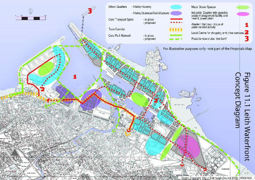
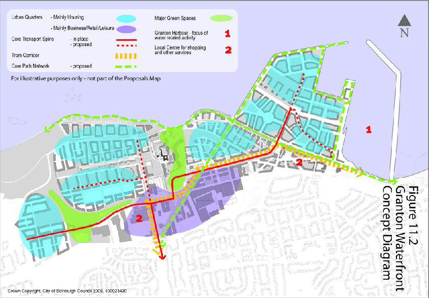
- transport measures agreed with the Council, including a contribution to the proposed tram network and other necessary public transport improvements, the eastwards extension of Ocean Drive and the provision of a network of paths for pedestrians and cyclists, including an east-west path that will form part of the city-wide coastal promenade (safeguarded routes for these are shown on the Proposals Map and Figures 11.1 and 11.2)
- the negotiation of financial contributions, or a contribution in kind, for the provision of other measures and facilities made necessary by the development, which could include the provision of additional school places in existing schools, the construction of new schools and the development of new publicly accessible open spaces.
11.5 Regeneration proposals and developer interest are also likely to emerge in the longer term for the one remaining extensive area of commercial uses, between Seafield and Portobello. The principles set out in the above policy will be applied to this area at the appropriate time.
General Principles
11.6 Similar ambitions have informed the strategies and the visions for both Granton and Leith. In both areas there will be:
- a broad mix of uses, a finer grain of development, incorporating a high standard of design
- higher density of development leading to a critical mass of housing and business uses and a greater intensity of activity that will generate urban vitality and support and be supported by high quality public transport
- a reduction in the influence of the car in the design and layout of the area and encouragement for walking and cycling
- development will have a strong urban form and scale, generating a permeable and legible perimeter block structure, in which buildings provide some kind of activity to all public ground floor frontages
- special attention will be paid to the public realm in which a hierarchy of streets, civic spaces and parks will be created around locations and features of special interest, encouraging people to explore the area and providing focal points for events and activities
- housing development will include a proportion of affordable homes, in accordance with standards applied across the whole city
- development will provide for a high level of energy efficiency, and an element of sustainable energy production including combined heat and power generation, to contribute towards the Council's goal of low and zero carbon growth
- access to the coastal edge and a coastal path. The Council has since developed its ideas about this coastal path, which will be a substantial promenade, 10 metres in width where this is achievable, linking with the Portobello Promenade and Silverknowes coastal footpath.
Leith Waterfront Area of Change
11.7 The Leith Docks Development Framework, (prepared for both Forth ports and the Council, and approved by the Council as supplementary planning guidance in 2005) covers the main, eastern and western, docks area and adjacent land and buildings (WAC 1b). About 170 hectares of land is expected to become available in this area over a period of up to 30 years, as industrial and port-related activities cease or are relocated to other ports around the Forth. Development in Western Harbour (WAC 1a) to the west is proceeding in accordance with comprehensive planning consents within the framework of a design master plan. The Council has prepared a development brief for industrial and disused land at Salamander Place (WAC 1c), an area which will be developed in accordance with the principles agreed for the main docks area.
Figure 11.1 Leith Waterfront - Concept Diagram
View larger Leith Waterfront map (jpeg, 1188kb)
11.8 The development of these areas will make a major contribution to the city's growth needs: 3,000 homes have been approved for Western Harbour; up to 18,000 are envisaged for Leith Docks. However, the construction of the tram to its projected terminal at Ocean Terminal and its longer term extension to Newhaven and Granton is crucial to the realisation of the area's full potential. Key elements of the vision for the docks area, which will be extended into adjoining areas, are:
- a series of residential neighbourhoods providing a mix of house types, sizes, tenures and affordability to meet different needs and create balanced communities and lively neighbourhoods, together with two new local shopping centres, one of which will contain a major foodstore (read Proposal S6), schools to meet needs and other essential services
- housing developments to graduate from medium to high density, with the highest densities in the most accessible locations adjoining public transport routes and tram stops, lower densities adjoining the eastern breakwater
- a new mixed use, predominantly business quarter between Ocean Terminal shopping centre and Victoria Quay, anchoring the tram at its initial terminus
- an area of consolidated industrial and storage uses at the east, on land around the existing rail head, which will also be reserved for possible development with a waste management facility to replace the existing facility at Powderhall. The site would be suitable for a combined heat and power plant (read Proposal BUS 3)
- development generally to have a strong urban character and scale, with blocks of development defining a network of public spaces and streets and enclosing more private interior spaces for residents' use
- special attention to be paid to the quality of the public realm, which will be designed to give priority to the needs of people on foot, and draw people into the area, along quay sides and the coastal edge, linking historical features, structures and buildings in ways which evoke Leith's maritime, seafaring history and bring the heritage to life
- a network of green spaces which will include three significant areas of open space, one in the Western Harbour development, one more centrally located, one at the east to link with Leith Links (read Proposals OSR 2, 3 & 7)
- a coastal path around the outer edges of the site and forming part of the 'Almond to the Esk' coastal promenade project will be a prominent part of the path network; another key route will extend the Water of Leith Walkway from the Shore out to the Martello Tower
- a new deep water cruise liner terminal is proposed to be built in tidal waters, subject to their being no adverse impacts on the nature conservation importance of the Firth of Forth Special Protection Area
- tourism, leisure and entertainment uses.
Granton Waterfront Area of Change
11.9 The vision and framework provided by the Granton Master Plan seeks to integrate the development activities of three land owner/developers: Forth Ports, National Grid and Waterfront Edinburgh, the last part-owned by the Council. Master plans have subsequently been prepared by each of the land owners for their holdings, and planning applications have been approved. Major infrastructure items have been built, including the main spine road and major developments have been completed for Telford College and Scottish Gas. The total amount of housing approved exceeds 8,000.
Figure 11.2 Granton Waterfront - Concept Diagram
View larger Granton Waterfront map (jpeg, 185kb)
11.10 Developments will have the same urban, higher density character as for Leith Docks redevelopment, and include:
- new residential and business quarters to be formed and a network of streets and paths that will integrate the area with adjoining neighbourhoods and draw people to the water's edge
- a significant area of green public open space that will provide a setting for the historic Caroline Park House and will extend down to a new beach, and other industrial buildings and relics retained to help engender distinctiveness and visual interest
- a coastal path which will form part of the 'Almond to the Esk' coastal promenade
- mooring facilities and water features to be formed, and Middle Pier retained as a 'working' pier, in Granton Harbour
- new schools to meet needs and two new local shopping centres to be created, one adjoining Telford College and including a major foodstore, the other on West Shore Road opposite Granton Harbour (read Proposal S5)
- tourism, leisure and entertainment uses.