Chapter 5: Housing and Community Facilities
Background
5.1 The population of Rural West Edinburgh is approximately 31,000, the great majority of whom live in the main towns and villages. The population structure is relatively youthful with almost two-thirds under 45 and 15% over 65. Average household size in the area is significantly higher than the Edinburgh average, due mainly to a lower percentage of single person households and a higher percentage of households with more than three people.
5.2 Over 80% of dwellings in this area are owner-occupied compared to two- thirds for Edinburgh as a whole. Only 10% of the houses are in the local authority rented sector. Over 60% of the Council's original stock in the area has been sold to sitting tenants and turnover of the remaining stock is low. The Edinburgh Housing Needs Assessment identified that for every Council house vacancy in the Rural West Edinburgh area, there are 37 new waiting list applicants. The Council's Housing Department has identified a lack of affordable rented housing in the area. Housing development in the last 20 years has focused on the private sector market with major developments in Queensferry, Kirkliston and Balerno.
5.3 The Edinburgh Housing Needs Assessment identified that a high proportion (24%) of households purchasing property in the Rural West Edinburgh area, between 1995 and 2000, came from outside Edinburgh. Citywide, 17% of purchasers came from outside the city. House prices in the Rural West Edinburgh area are similar to the city average, the average sale price in 2001 being £100,000 (compared with £105,000 citywide).
5.4 The term 'community facilities' covers the wide range of services important for the well being of local residents and the vitality and attractiveness of towns and villages. It includes schools, child care, health services, halls and community centres, churches, sports centres and libraries. The Council is one of a number of agencies providing such services. It has direct responsibility for education, social work, and the management of public sports centres, libraries and community centres. This public provision is complemented by private sector facilities. Within Rural West Edinburgh, Currie, Balerno and Queensferry High Schools have 'community high school' status where the wider community is encouraged to make use of school facilities. New libraries have recently been built at Kirkliston, Currie and Ratho. The Council still wishes to provide a new permanent library in Balerno, though this is not currently programmed. A new doctor's surgery has been built at Ratho as part of a housing development and the Pentland Medical Centre at Currie has recently been extended.
National Planning Context
5.5 Scottish Planning Policy 3: 'Planning for Housing' sets out the Scottish Executive's housing and planning policy objectives. The planning system has a key role in guiding housing to sustainable locations, delivering an adequate supply of housing land and creating quality residential environments. New housing areas should be easily accessible by public transport and allocations should flow from a long-term, plan-led settlement strategy. Local plans should specify densities for new housing areas and the emphasis on brownfield and infill sites as first choice locations remains. Planning for housing should be based on up to date housing plans and strategies. SPP3 provides for the delivery of affordable housing through the planning system based on housing needs assessments. This plan has been written to conform to the SPP.
5.6 Through the publication of 'Designing Places' and SPP1, Scottish Ministers have signalled the importance they attach to achieving improvements in the design and quality of new development and bringing long-term benefits to the urban and rural environment. The way that buildings, old and new, work together and create the spaces and sense of place that have such an influence on the quality of life for communities, is also important. SPP1 requires local plans to set a framework within which developers can work, addressing issues of context and form such as scale, layout, density, massing and height.
5.7 There are also two Scottish Executive Planning Advice Notes of particular relevance to housing in Rural West Edinburgh. PAN 44: 'Fitting New Housing Development into the Landscape' aims to achieve residential development which harmonises with its landscape setting and makes a positive contribution to the character of existing settlements. PAN 52: 'Planning in Small Towns' seeks to provide the context within which opportunities for change in Scotland's small towns (defined as settlements with populations ranging from 1,000 to 20,000) can be identified and promoted to help reinforce their character and identity. It addresses a wide range of issues including the function of the town, traffic growth, townscape quality and sense of place.
Structure Plan Context
5.8 The Edinburgh and the Lothians Structure Plan 2015 specifies that, in addition to the existing supply of housing land, new land for around 18,200 houses will be required. The Structure Plan settlement strategy is based on the need to give priority to brownfield land but also recognises the need for some new greenfield development if demand is to be met in full. The strategy is to focus most new development in 15 core development areas where infrastructure capacity exists or where new infrastructure would be cost-effective. The two uses which make the most demands on development land are housing and business. It is envisaged that each core development area will contribute to these strategic requirements in different ways. The maintenance and improvement of accessibility through the appropriate location of land uses and the development of transport networks is fundamental to the success of the strategy. One of these core development areas lies to the west of the city in this local plan area. The Newbridge/Kirkliston/Ratho area has been identified to accommodate land for 1,000 new dwellings to balance committed employment growth. The ELSP establishes that the development of strategic housing land should not proceed beyond infrastructure thresholds until necessary improvements are provided or committed. The remainder of the local plan area is specifically defined as an area of restraint.
5.9 Notwithstanding the above, a number of sites which have planning consent or are already identified in previous local plans, will continue to contribute to the existing land supply. In addition, appropriate infill development (including renovations, rehabilitation and redevelopment) is encouraged by the Structure Plan, provided there would be no harmful effect on the quality of the urban environment. Provision is also made for local plans to include mechanisms to achieve affordable housing.
City Housing Strategy
5.10 The Council's 'City Housing Strategy 2002-2007' (PDF,376kb) sets out a strategic framework for providing high quality affordable housing and meeting the Council area's housing needs and aspirations within the context of the resources available to the Council and its partners. The Housing Strategy confirms the Council's commitment to working corporately and in partnership with local people and a wide variety of agencies, including Communities Scotland, housing associations and the private sector, to maximise resources and achieve objectives.
5.11 The Housing Strategy sets five main challenges for the Council and its partners, the first three having land use implications. These challenges are that each household living in or moving to Edinburgh should be able to:
- find a home
- that it is affordable to them
- of good quality
- in a clean, safe and thriving neighbourhood
- where they can achieve independent living.
5.12 The focus for most new investment is elsewhere in the city outwith Rural West Edinburgh, but the Housing Strategy concludes that there is a city wide need for affordable housing, particularly housing for rent. The Council commissioned a housing needs assessment, which shows a strong continuing need to provide more affordable homes across the city in line with Scottish Executive advice in SPP3. The Council also aims to provide or facilitate appropriate housing for all community care client groups, including the elderly, people with physical or mental disability, and the homeless.
Local Plan Objectives
5.13 Two aims for housing in this plan flow from this national and regional context, and the local plan's strategy. Firstly, policies should reflect the continuing policy of development restraint applicable in Rural West Edinburgh and focus on the needs of the existing population. Secondly, the plan must deliver the Structure Plan requirement for a strategic housing allocation in the Newbridge/Kirkliston/Ratho area resulting in this local plan being required to allocate land for 1,000 units in that area. These objectives can, therefore, be set out, as follows:
Within the plan area generally:
- to consolidate the existing settlement pattern;
- to encourage appropriate infill development within the area's towns and villages, and identify appropriate new housing sites;
- to meet the housing needs of the area, including the provision of affordable housing, and particularly those of special groups;
- to ensure that all new housing developments are built to high standards of amenity, create safe environments in keeping with the character of existing settlements; and
- to protect and improve the amenity of existing residential areas and to secure adequate community facilities to serve them
In choosing sites for the strategic housing allocation:
- to give priority to the development of brownfield sites;
- where green belt sites are necessary, choose sites with least impact;
- to support sustainable transport objectives, particularly by having good access by public transport and making best use of existing infrastructure; and
- to allow for choice
Policies and Proposals
New Housing Development
5.14 Since the Finalised Local Plan was published in 1999, a number of housing sites have been completed, including at Station Road, Queensferry; Ravelrig West, Balerno; Newmains Farm, Newmains, Almondhill Steading, Kirkliston, and Harlaw Road, Balerno.
5.15 Housing allocations in the Finalised Local Plan 1999 were made in the context of the policy of restraint applicable in Rural West Edinburgh in accordance with the Lothian Structure Plan 1994. The Council continues to support the development of sites which already have planning consent and those which were previously identified for housing in that version of the local plan.
5.16 A detailed schedule of the housing proposals is provided towards the end of this chapter which only shows indicative capacities in some cases. Development briefs may be prepared by the Council in due course, particularly for unexpected 'windfall' sites which emerge during the plan period. There is uncertainty regarding the availability of the site at Springfield, Queensferry (HSG 2) which is currently owned by the Scottish Executive, having been acquired to facilitate a second Forth crossing. However, the Scottish Executive has yet to advise as to whether or not it intends to proceed with the second crossing proposal.
5.17 Where ownership is a serious development constraint, the Council may be prepared to use its compulsory purchase powers to bring land on to the market. The Council may also use such powers to assemble land for development.
Policy H1 - Identified Housing Sites
New development will be supported on sites which already have planning consent and those which were previously identified for housing in the 1999 Finalised Local Plan (HSG1-HSG8 of Schedule 1 at the end of this chapter). Should problems be encountered in the release of these sites, the Council may use its powers of compulsory purchase to let development proceed.
5.18 In meeting the strategic land allocation in the ELSP for land for 1,000 houses in the Newbridge/Kirkliston/Ratho area, national and structure plan guidance prioritises the development of brownfield sites, wherever possible. For this reason, the potential for brownfield housing development has been examined in this core development area. Some limited opportunities have been found in the Kirkliston area and it is proposed that these contribute to meeting the requirement.
5.19 Most of the strategic allocation, therefore, has to be met on greenfield land. Before preferred sites could be identified, a comprehensive assessment was carried out of all potential development sites in the 'core development area'. The assessment took account of planning policy and physical constraints and best use of infrastructure to choose the most sustainable sites. For example, issues such as areas of importance for flood control, hazardous pipelines and strategic public transport accessibility guided the choice of sites. The housing proposals in Newbridge/ Kirkliston/ Ratho are intended to balance employment growth in the area. However, many local residents will continue to work further afield. Significant improvements in public transport accessibility are, therefore, required to ensure a sustainable and socially just pattern of development occurs. In terms of timing, the new strategic greenfield housing allocations should not, therefore, proceed until these improvements are secured. This is likely to involve the completion of, or final commitment to, the West Edinburgh Tram to Newbridge. In the event of this not being delivered, alternative improvements will be considered, such as the completion of the tram to Ingliston, expansion of park and ride and provision of frequent reliable bus links with new public transport infrastructure.
5.20 In view of the previous use of land or land adjacent to some sites, it will be necessary to determine whether the land is contaminated. Permission will not be granted to proposals which do not deal adequately with any contamination or ground stability issues affecting sites, particularly, HSP2, HSP3 and HSP8 detailed below.
5.21 Most of the allocation will be provided on land to the north and east of Kirkliston (29.4 hectares). This will provide a new northern boundary to the town and will link well with the existing community. The increased population should also help underpin existing community facilities and encourage new ones. Given the scale of the development proposed, a summarised planning brief, addressing important development constraints and principles, is included at the end of this chapter. The Council also intends to prepare a full development brief for this site.
5.22 The site previously occupied by Drambuie on Main Street West, Kirkliston is an opportunity to develop over four hectares of brownfield land in a predominantly residential area. The development solution should incorporate new open space areas and north/south pedestrian links through the site.
5.23 Similarly, the Kirkliston Distillery 3.5 hectare site, which is located to the west of New Liston Road, and to the north of Gateside Road, offers a further opportunity for brownfield housing development in this community. The site is currently occupied by a range of brick and stone industrial buildings, previously used as a malt extract factory. The Council accepts that the redevelopment of the site for business is unlikely and, therefore, a housing development would in, principle, be supported.
5.24 Site HSP4 is the former nursery site at Newbridge. It is a small site of just over one hectare and offers further brownfield housing land to meet ELSP requirements.
5.25 Housing development is proposed on land to the east of Ratho Station to meet structure plan requirements and contribute to the regeneration of the village. This site is therefore removed from the green belt. Proposals should accord with the principles set out in the WESDF. These include the need to retain the existing football pitch as a focal point for the extended village and provide a new community building adjacent to the open space. As an alternative to providing a new community building at this location, the development or enhancement of community facilities elsewhere in the village may be acceptable.
5.26 The Craigpark Quarry (CPQ) site, listed below, is a worked out quarry that is a special circumstance requiring an individual approach. Normally, worked out quarries start as greenfield and should be restored to greenfield. However, CPQ is in an unusual position of having no planning mechanism to require its restoration to greenfield. A housing development of 80 dwellings on approximately seven hectares of the overall site is considered acceptable as a component of a scheme to restore the quarry. A larger number of dwellings may be permitted if it is demonstrated that this is necessary to enable an acceptable restoration scheme. Developers will be expected to discuss with the Council, provision of school places for children of secondary school age, who will be living in these dwellings. Provision of additional school accommodation may be needed and, if so, developers will be expected to contribute to the cost of this. The remainder of the quarry is covered by Policy E5 : 'Development in Green Belt and Countryside Areas' and the entire site is covered by Policy M6 : 'Reuse of Craigpark Quarry'. The Council intends to prepare a full development brief for the entire site providing additional guidance on the estimated capacity of the site and the expected level of site restoration.
5.27 The Freelands Road site is one that offers the prospect of a very high quality of residential environment. The site is partly within Ratho Conservation Area and adjoins part of the Union Canal, a scheduled ancient monument. Development on this site must, therefore, be of exceptional quality and sensitivity to its surroundings. There is an opportunity to create a new alignment for the westernmost part of Freelands Road, bringing it to a new junction with Baird Road in the vicinity of the public car park. Provision for public car parking must be maintained within the site. Part of the site must be set aside for a marina. The design of the marina and its associated buildings must complement and enhance the character of the canal and the conservation area. The marina must be an integral part of the residential development, and, to avoid unacceptable disturbance to future residents, it should be constructed before completion of any houses in the west half of the site. The design and construction of the marina must ensure that the integrity of the canal is maintained at all times. Use of the marina will be restricted to purposes connected with boat travel. Mooring of houseboats will not be permitted. Apart from the marina, built development must generally be separated from the canal by a zone of public open space. The east side of the site is not well-defined in landscape terms. A belt of planting somewhat more substantial than that which has recently been created on this boundary of the site will be required if the east side of the development is not designed to be outward-looking. The settlement boundary for Ratho includes a small area of agricultural land between the north-west boundary of the housing site and Freelands Road. The possibility that this area may be developed at some time in the future should be recognised in the layout design for the housing site. Developers will be expected to discuss with the Council provision of school places for children of secondary school age who will be living in the development. Provision of additional school accommodation may be needed and, if so, developers will be expected to contribute to the cost of this.
5.27a An additional housing proposal is identified on the site of the former Continental Tyres factory in Newbridge to promote housing-led regeneration in the village. Whilst Newbridge remains an important business location, the need for additional housing and related facilities to breathe new life into the local community outweighs the contribution that the site makes to the citys economic land supply in this instance. This proposal is not required to meet strategic housing requirements. However, the site will contribute to the overall housing land supply and provide additional housing choice in one of the Structure Plans core development areas. There are also advantages in terms of bringing a large derelict site back into beneficial use.
5.27b Housing development at this location does raise some environmental concerns, for example proximity to industrial uses and impact of aircraft noise, which will need to be addressed through detailed layout and design. Proposals should accord with the principles set out in the WESDF. These include the inclusion of community facilities in order to create a more sustainable development, a restriction on development and uses within the area covered by the airport public safety zone, consideration of flood risk and the relationship with existing uses.
5.27c It should be noted that a proportion of the Newbridge/Ratho/Kirkliston core development area forms part of the catchment area of denominational primary and secondary schools in West Lothian and therefore West Lothian Council (WLC) is the education authority. The Edinburgh and the Lothians Structure Plan Action Plan identifies the need for developer contributions to fund the expansion of existing primary schools and the provision of a district wide denominational secondary school in West Lothian. Therefore, developers with proposals for housing development which are within the catchment area of a WLC school, will be expected to make an appropriate contribution towards the new school requirements to the satisfaction of the City of Edinburgh Council (CEC) and WLC by way of Section 75 or other legal agreements. Alternatively, a joint CEC/WLC catchment review may be undertaken, funded by developers, with the aim of aligning denominational school catchment boundaries with council boundaries.
Policy H2 - Strategic Housing Land Allocations
Housing development will be supported on the following sites:
| Reference | Location | Estimated Capacity (Units) |
|---|---|---|
| View HSP1 on map | North Kirkliston | 610* |
| View HSP2 on map | Main Street West, Kirkliston | 90 |
| View HSP3 on map | Kirkliston Distillery, Kirkliston | 103 |
| View HSP4 on map | Newbridge Nursery, Newbridge | 25 |
| View HSP5 on map | East of Ratho Station | 50 - 100 |
| View HSP6 on map | Craigpark Quarry, Ratho | 80 |
| View HSP7 on map | Freelands Road Ratho | 100 |
| View HSP8 on map | Former Continental Tyres Site North, Newbridge | 500 |
| Total Units | 1,558 - 1,608 |
5.28 The development of infill sites within existing built-up areas for housing, including the redevelopment of brownfield land, will be supported where there would be no conflict with neighbouring uses or the provisions of the local plan. Such developments can use or reuse land without the need to expand settlement boundaries into the countryside, but this must be balanced against the need to protect valuable open space or existing community facilities within settlements. While these sites will generally be found within the areas allocated as 'residential areas within defined settlement boundaries', this land use designation does not imply automatic approval; the individual site characteristics and the effect of additional housing on existing uses and on residential amenity will be taken into account. In particular, the Council will oppose schemes which it considers to represent overdevelopment or 'cramming' of sites. Any unforeseen or 'windfall' developments arising in the local plan area will contribute to the strategic housing land supply.
5.29 An issue of particular concern relates to the infill development in the grounds of traditional stone built villas. These are vulnerable to loss of character and amenity through loss of garden ground and trees. The Council has prepared detailed design guidance to control such development and this is endorsed in Policy E44 of the Environment chapter. This policy will be applied along Lanark Road West in Currie and Balerno and to other appropriate properties, particularly those within Conservation Areas.
Policy H3 - Infill Sites
The Council will support housing development on infill sites within the built-up areas, as defined on the Proposals Map, provided it would:
- not lead to loss of valuable open space or community facilities;
- be compatible with neighbouring land uses;
- not be detrimental to the character and amenity of the area; and
- not be in conflict with any other provision of the local plan.
5.30 The Council generally supports the conversion of suitable buildings within existing urban areas to residential use and the sub-division of such buildings or of existing houses to provide new or additional smaller residential units, usually flats. Such conversion and sub-division can improve properties and adapt them to modern needs, provided the resulting standards of accommodation, including room arrangements are satisfactory, that the intensity of new residential use proposed is not damaging to the amenity of the area, or to its architectural or historic character, and that car parking can be provided satisfactorily. In particular, any on-street parking difficulties should not be worsened. Many existing houses, particularly those in historic areas, while large by present day standards are not excessively so and their preservation is important to local character. The particular characteristics of such properties and the surrounding area will determine the acceptability of their sub-division.
Policy H4 - Conversion and Sub-division
The change of use of suitable non-residential buildings to housing, and sub-division of a residential building to form new or additional residential units, will be permitted in the built-up areas defined on the Proposals Map, provided:
- there would be no unacceptable loss of amenity or architectural/historic character;
- satisfactory standards of accommodation and access to garden amenity can be achieved;
- satisfactory arrangements for adequate car parking facilities can be made; and
- the building is not in a protected retail frontage or centre.
Design of New Development
5.31 With all forms of new housing development it is important that a properly planned environment is provided from the outset as opportunities to rectify any deficiencies later may neither be possible nor economically achievable. The Council will, therefore, ensure that all new housing development is sympathetic to its environment and that existing mature trees, vegetation and landscape features are retained. Developers will be encouraged to use native species in new landscaping schemes and to retain or create features of specific ecological interest. Safety is a key concern and the inclusion of measures to aid crime prevention and encourage defensible space will be encouraged. All new housing should be well laid out in terms of accessibility to public transport services, access, car parking and the incorporation of traffic calming principles, favouring security for pedestrians and cyclists. More detailed guidance is provided in Chapter 7 on Transport.
5.32 Housing developments should provide adequate amounts of amenity and recreational open space in line with the Council's current standards. The Council has recently reviewed its standards for the provision of recreational and amenity open space in housing developments. These standards are set out in the Development Quality Handbook guideline entitled 'Open Space and Ancillary Facilities for New Housing Developments' (PDF,70kb). Open space provision which exceeds the minimum standards may be required if existing landscape features, for example, woodland or tree belts, are to be retained. The Council also recognises that housing developers should not be expected to make good existing deficiencies in open space provision and that requirements for open space should be related to the scale and nature of the development proposed. The Council is preparing an 'Open Space Framework' which incorporates an audit of existing open space. When complete, this will provide further guidance in relation to the need for open space.
5.33 In ensuring that all new housing development harmonises with and reflects local character, developers should take account of the advice in PAN 44: 'Fitting New Housing Development into the Countryside', PAN 52: 'Planning in Small Towns' and PAN 67: 'Housing Quality' as well as the 'Design of New Development' policies in the Environment chapter. New development will be expected to reinforce a sense of place and the character of the surrounding landscape or urban area, with careful attention being paid to landscape fit, relationship to the existing urban form and good design. The Council will expect developers to pay particular attention to matters of design, environmental quality and energy conservation in all new housing development proposals, in accordance with national policy and advice.
Policy H5 - Quality Standards for New Housing Developments
All new housing development should harmonise with and reflect the character of its surroundings and should:
- maximise public transport links;
- provide for access for pedestrians and cyclists;
- create a residential environment which provides amenity, safety and security, having regard to the special needs of women, children, the elderly and people with disabilities;
- provide open space in line with the Council's guideline entitled 'Open Space and Ancillary Facilities for New Housing Developments' and the Council's 'Open Space Framework';
- provide parking in accordance with the Council's approved standards, unless otherwise agreed; and
- incorporate energy efficient site layouts, building design and landscaping.
Residential Amenity
5.34 Housing is the dominant use in the towns and villages of Rural West Edinburgh. In the established residential areas within defined settlement boundaries, the protection of residential amenity is the main concern. While the local plan objectives encourage the introduction of other uses, particularly those generating employment, in an effort to encourage self-sufficiency within communities, development incompatible with neighbouring residential uses will be resisted. Unacceptable uses are those which would adversely affect residents because of noise, dust, increased traffic generation or other disturbance, particularly late at night. It is unlikely that significant office, industrial or warehousing development would be appropriate and accordingly, the Council will direct these uses to areas suitable for commercial uses. However, this policy does not rule out the introduction of small- scale businesses or community facilities within predominantly residential areas.
Policy H6 - Protecting Residential Amenity
Development which would significantly damage residential amenity will not be permitted in residential areas within defined settlement boundaries.
5.35 The Council will seek the co-operation of other agencies such as housing associations, the private sector and Communities Scotland to increase the range of housing type, size, tenure, client group and price in each community in Rural West Edinburgh. The Council's role as housing authority is now increasingly as an enabler. It can continue to assemble land, using its powers of compulsory purchase, where necessary, and may subsequently transfer the ownership of ground to housing associations and the private sector for development to meet housing needs.
Housing Choice
5.36 Affordable housing is defined as housing that is available for rent or for sale to meet the needs of people who cannot afford to buy or rent the housing generally available on the open market. The Councils policy is currently based on the Lothian Housing Needs and Market Study published in December 2005 which provides an examination of need for the period to 2010. The levels of provision proposed in this local plan will contribute towards meeting this need. The Council, together with the other Lothian Councils, is now assessing needs within the region for the period beyond that date. Further information on housing needs is set out in the citys local housing strategy, which is also under review.
5.37 Government policy, through Scottish Planning Policy (published February 2010), indicates that policies in development plans may seek a percentage affordable housing contribution from new housing developments. It identifies 25% of the total number of housing units as affordable housing as a benchmark figure. The guidance emphasises the importance of meeting the need for affordable housing at a local level. PAN 74 Affordable Housing provides detailed guidance on how the appropriate level of affordable housing may be provided through the development plan process. The National Planning Framework (NPF2, July 2009) identifies the lack of affordable housing in the Edinburgh and Lothians area as being a particular issue.
5.38 With the exception of sites proposed for development with fewer than twelve houses, all sites will in principle be considered suitable for affordable housing provision. A key aim of the policy is that affordable housing should be integrated with market housing on the same site and should address the full range of housing need, including family housing, where appropriate. Provision on an alternative site may be acceptable where the housing proposal is for less than 20 units or if there are exceptional circumstances.
5.39 High land values have made it increasingly difficult for social landlords, the main developers in recent years of low cost housing, to acquire sites on the open market. The policy is intended to ensure that a proportion of eligible sites are made available to social landlords or other providers to build for rent or low cost home ownership. Further policy guidance on affordable housing requirements is set out in the Councils affordable housing guideline. The details of provision, which will reflect housing need and individual site suitability, will be a matter for agreement between the developer and the Council.
Policy H7 - Affordable Housing
Planning permission for residential development, including conversions, consisting of 12 or more units should include provision for affordable housing amounting to 25% of the total number of units proposed. For proposals of 20 or more dwellings, the provision should normally be on-site. Whenever practical, the affordable housing should be integrated with the market housing.
5.40 Scottish Planning Policy 3 (SPP3) states that, where a need is demonstrated, suitable locations for gypsies/travellers sites should be identified in local plans and policies set out for dealing with applications for small privately owned sites. While it is not possible or appropriate at the present time to identify specific sites for travelling people/gypsies, the current city wide search may result in sites being identified in Rural West Edinburgh. These may be larger permanent sites or smaller temporary 'stopping places'.
Policy H8 - Travelling People
Sites for travelling people will be supported provided:
- they would not conflict with policies E5 and E6 covering the Green Belt and countryside and other policies aimed at the protection of designated areas;
- they would not have an adverse environmental impact on neighbouring uses and, in particular, housing through an increase in noise, road traffic movements and other disturbances;
- they can be made compatible with the character and appearance of the surrounding area through appropriate landscaping and screening; and
- they can reasonably access local services and facilities e.g. shops, hospitals, schools and public transport.
5.41 Another strategic objective of the Housing Strategy is to ensure a range of provision to meet housing needs of those requiring support. Whilst many of these needs (including those of the elderly, people with physical or mental disability, and the homeless) can be met through mainstream housing, there may also be a requirement to develop specialist housing provision. Encouragement will be given, particularly to housing associations, for the provision of 'care' housing, in order to meet the requirements of each community. The Council will aim to identify localised needs of community care groups and seek additional sites suitable for the development of appropriate forms of housing.
Policy H9 - Increasing Housing Choice
The Council will encourage and promote developments designed to increase the range and type of housing available within the local plan area. In particular, it will encourage housing providers to increase the range of rented accommodation available and to meet the special needs of young people and 'community care' groups such as the elderly and people with disabilities.
5.42 There has been increasing pressure throughout Edinburgh for the development of private residential care facilities, mainly nursing homes. While a number of new build schemes have been developed, there has also been pressure for the change of use of older, larger residential properties. Nursing homes are likely to be best suited to areas of predominantly residential use, subject to consideration of the individual characteristics of the proposed development and locality. Proposals should be well located in relation to public transport and local facilities, for example, shopping, health services, public open space and community services. In addition, proposals should be compatible with neighbouring uses, particularly with regard to residential amenity, and be appropriate in terms of scale and character, minimising any 'institutional' appearance. Scale and impact will also be important considerations to be taken into account in regard to proposed future extensions of existing nursing homes.
Policy H10 - Nursing Homes
Nursing homes, including new build and changes of use, will be acceptable within residential areas within defined settlement boundaries:
- the scale and character of the proposal is appropriate to the area;
- no detrimental effect on residential amenity would result, including the effect of traffic generation;
- good accessibility to public transport and local facilities can be assured; and
- appropriate amenity can be provided for the facility.
5.43 The Council aims to secure the provision of a full range of local services which will benefit all sectors of the population and help to create more self-sufficient communities. Existing facilities should be retained or replacements provided where need can be demonstrated. Buildings constructed for community purposes, such as churches and schools are frequently distinctive in design and contain specialised accommodation. These buildings are often assets or landmarks within the community and, should they become vacant, consideration should be given to possible reuse for alternative community facilities. The provision of new educational, health care, recreational, childcare and other community services will be supported, provided that proposals do not conflict with existing uses, residential amenity or other local plan policies. New facilities should ideally be located in areas easily accessible from residential areas. In Rural West Edinburgh, some schools contain facilities such as sports halls, meeting rooms and swimming pools, which are presently underused outwith school hours. The use of these facilities by local residents can help meet the needs of the community through better use of existing resources.
Policy H11 - Community Facilities
The Council will support the retention of existing community facilities where there is a proven need and no suitable replacement facilities are available. Proposals for new community facilities to serve local needs will be supported, except where contrary to other local plan objectives, such as the protection of residential amenity. The dual use of educational facilities will be encouraged, wherever practicable.
Monitoring of Housing Land
5.44 The Lothian Councils are committed to the maintenance of an effective five year housing land supply and will continue to assess this through an annual housing land audit. Policy HOU10 of the ELSP requires the Council to bring forward additional housing land in a core development area, either through a local plan alteration or through granting planning consents, if Edinburgh's contribution to the Lothian-wide five-year supply falls below 90% of its expected level, and the shortfall in the Lothian-wide supply is also more than 10%.
| Proposal Reference | Location | Ownership | Site Capacity |
|---|---|---|---|
| View HSG 1 on map | Kinleith Mill, Currie | Private | To be established |
| View HSG 2 on map | Springfield, Queensferry | Scottish Executive | 150 |
| View HSG 3 on map | Baird Road, Ratho | Private | 6 |
| View HSG 4 on map | Hawthornbank, Queensferry | C.E.C. | 23 |
| View HSG 5 on map | Stewart Terrace, Queensferry | Private | 117 |
| View HSG 6 on map | Port Edgar, Queensferry | C.E.C. | To be established |
| View HSG 7 on map | Society Road, Queensferry | Scottish Executive | To be established |
Briefs
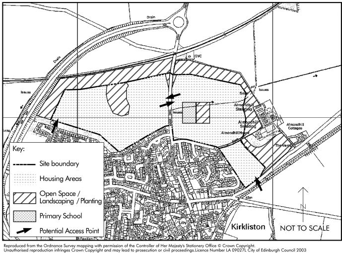
HSP1 North Kirkliston
- Site Area: 29.4 Hectares
- Ownership: Private
- Proposed Use: Housing, primary School, public open space
- Estimated Maximum Site Capacity: 610
- Housing Tenure Split: 75% owner-occupied / 25% affordable
The Edinburgh and the Lothians Structure Plan 2015 identifies Newbridge/Kirkliston/Ratho as an area where new housing could balance its emergence as a business location and help meet new regional housing targets. A strategic housing allocation of 1,000 units is made which this local plan has to translate into specific housing proposal sites.
To achieve this, some new housing land is allocated at Ratho, Newbridge and Ratho Station and on brownfield sites in Kirkliston. But the bulk of the allocation is on open land to the north and east of Kirkliston.
Summary of Proposed Scheme
This major development to the north of Kirkliston best meets a range of planning factors. It will provide a new, defensible northern boundary to the town and will link well to the existing community. The increased population should also help underpin existing community facilities and make the introduction of new ones more viable. This is a significant proposal and there are a number of important physical and policy constraints and principles that developers should take into account when preparing detailed proposals for the scheme. The essential and desirable features are summarised below.
Key Development Constraints
- High-pressure gas pipeline: development must be kept at least 50m from this pipeline. The Health and Safety Executive can advise on detailed requirements.
- Schools capacity: the existing primary school is operating at capacity and is forecast to remain so. Due to the scale of development proposed, a new single-stream primary school will need to be provided to serve the new housing. An extension may also be required at Queensferry secondary school to accommodate the proposal. Developers should also note that the scheme would feed to denominational schools in West Lothian. These are currently at capacity and West Lothian Council should be contacted to establish the level of developer contributions required to extend capacity.
- The Newbridge waste water treatment works has limited spare capacity to serve significant new development. It would need to be upgraded to serve this scheme. Scottish Water should be consulted to establish the scale of contribution required to overcome this constraint.
- Listed Buildings: development must respect the settings of Almondhill Farmhouse (C(S) listed) and Almondhill Steading (B listed). Land immediately to the west of these structures must be kept open, as indicated on the map below.
Essential Features
Schools: 2 ha should be reserved for a new single-stream primary school in the general location as shown on the map. There should be a significant level of community access to the school and dual use of its playing fields and other facilities.
Transport: Road access to the western part of the larger site should be taken from the B800 and Kirklands Park Street. The eastern part should be accessed from the B800 and the road to Almondhill Cottages (Burnshot Road), or link into Almondhill Road. A road layout based on connecting roads around perimeter blocks should be provided.
Road access linking Kirklands Park Street to the B800 Queensferry Road should not encourage through traffic but should provide a convenient public transport route into the development. The new access road from the B800 into the eastern site should also discourage through traffic should it be necessary to continue this road through to Burnshot Road.
A full transport assessment will be required to assess the current transport situation within Kirkliston and the surrounding routes to and from the city and how these will be affected by the scale of development proposed. A developer contribution will be required towards the development of the West Edinburgh Tram to Newbridge. This shall be equivalent to a Zone 3 contribution as set out in the Council's development quality guideline on tram contributions.
The basic route layout should connect both with existing development and the street structure. The development will be expected to contribute fairly and fully to its transport impacts. In particular, contributions will be sought towards improving public transport and walking and cycling links. Public transport improvement must include measures to ensure that there is a bus service between Kirkliston and the tram at Newbridge in which buses are timed to coordinate with the tram timetable and, which permit purchase of a single ticket for journeys that combine use of the bus and tram. Further contributions will be sought for the upgrading of surrounding roads and junctions.
If for any reason there is a delay in the construction of the tram to Newbridge, construction of houses at North Kirkliston shall not begin until arrangements have been made for an increased frequency of bus services between Kirkliston and Edinburgh and for implementation of bus priority measures to decrease journey time.
Priority should be given to pedestrians with the aim of providing the most direct routes with maximum safety. Pedestrian and cycle access to the new school should be provided from all parts of the development and must be direct, convenient and safe. A crossing facility (probably a Toucan crossing) will be required on the B800 Queensferry Road.
It is possible that public transport operators will continue to use the B800 and the B9080 as their main bus routes through Kirkliston and choose not to penetrate the new development. Therefore, good footway links to the B800 and convenient bus stops will be required. However, it is important that public transport is encouraged to penetrate the development and, therefore, any proposals should not preclude this when designing the main access roads.
Landscape Treatment: extensive landscaping treatment is required, as shown on the map below. This is needed to mitigate noise from the A8000 and to improve views from the development. There should also be a robust framework of structural planting to provide a mature environment. Existing features of interest like trees and hedges should be retained.
Affordable Housing: the scheme will be treated as one development for the purposes of calculating the affordable housing requirement. 25% of the housing units should be affordable and be provided in at least two separate parts of the site. At least 70% of the affordable element should be for social rented housing.
The scheme should include Sustainable Urban Drainage (SUDS) measures, where required, in line with Council supplementary planning guidance.
The scheme must not lead to coalescence with the listed Almondhill Steading development to the east. The development should complement the existing wood at Almondhill House and the Steading by incorporating additional tree planting and landscaping to improve the setting of the listed building. The existing footpath link to the village which runs along a ridge line should be protected and enhanced through additional planting.
Culs-de-sac should be avoided: the basic layout should be designed to allow access through the site by public transport and to deter external traffic using the road system as an unofficial bypass.
Desirable Features
Circulation should be designed to integrate the scheme with the existing town and new neighbourhoods should be linked by roads, pedestrian routes and cycleways.
A mix of house types and heights is encouraged. Some 3-storey flatted development will be acceptable in certain parts of the area to create landmark features but the repetitive use of standardised house types will be an opportunity lost and will be resisted.
Development should avoid the highest parts of the site.
'Green Gateways' incorporating woodland tree planting should be provided on the B800 and on the road to Almondhill Cottages to soften the impact of the new development.
Open spaces should form the focus of the two parts of the site and allow woodland tree planting. There should be a hierarchy of open spaces throughout, which provide a network of open spaces with pedestrian and cycle links. In addition, two main spaces should be included. The space to the west (see plan) of the B800 is the highest part of the west site and should be a focal point. The other to the east could be for dual school and community use.
A natural landscape structure should be provided with tree groupings rather than belts to create an attractive setting, including green gateways.
The layout should be in the form of groups or blocks, with the frontages forming the edge of blocks, to clearly define public front and private rear gardens.
Kirkliston's path and cycle way system should be extended throughout the new development.
Proposals should include a Design Statement, developed in consultation with the Council.
The planned new housing will be easily accessible to the existing shopping and other high street facilities on Main Street. It is not expected that significant new shops are needed to serve the proposed development, although small corner shop type convenience units will be supported.
Implementation
The Council will prepare a comprehensive planning brief for the proposed town expansion scheme which will provide more detailed guidance to prospective developers. In preparing this brief, further consideration will be given to the proposed location of the new primary school. When approved, this would have the status of supplementary planning guidance and will be developed in full consultation with the local community, developer interests and other public and private stakeholders.
HSP1 North Kirkliston