Chapter 6: Economic Development and Tourism
Background
6.1 The main concentrations of employment in Rural West Edinburgh are at Ratho Station and Newbridge, Edinburgh Airport, Queensferry and Heriot- Watt University's Edinburgh Campus at Riccarton.
6.2 Rural West Edinburgh is a gateway to the city by road and air and is, consequently,attractively located for inward investment. The potential for new business development needs to be balanced with green belt and countryside policy and the strategic approach of development restraint. Rural West Edinburgh competes with other business locations in the Lothians and beyond, including South Gyle, Edinburgh Park, East Mains Industrial Estate in Broxburn, Livingston and South Fife.
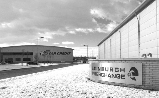
6.3 Newbridge is a major commercial location for storage and distribution activity, benefiting directly from good and improving access by all transport modes. This has been underpinned by recent large scale developments including 'Edinburgh Interchange' and 'Edinburgh Gate'. Traditional industrial sites, such as that previously occupied by Continental Tyres, are likely to be redeveloped over time for modern business uses and Newbridge is now being increasingly seen as an accessible and desirable location for office development.
6.4 The unemployment rate in the Rural West Edinburgh area is lower than the Edinburgh average. Approximately one in five of the area's working population is employed in the local plan area, with one third working in central Edinburgh. A higher than average proportion of the working population is employed in the manufacturing sector, reflecting the nature of local businesses.
6.5 A trend in Rural West Edinburgh has been the decline of traditional local industries, most notably the closure of the paper mills in Currie and Balerno. The development of new business and industry has been fairly slow throughout Rural West Edinburgh and a significant proportion of the land allocated for this use in the first finalised plan, and earlier local plans, is still available.
6.6 Most of the major large land users in Rural West Edinburgh are in the Edinburgh Green Belt where a balance needs to be struck between accommodating new development and maintaining green belt principles. Opportunities to travel to and from these facilities by public transport are limited at present, but major tram and rail improvements are planned. The Structure Plan requires masterplans to be prepared for the three major uses and approved by the Council.
6.7 Commercial tourism activity in this local plan area is growing, based on natural resources and historic assets. The main areas of interest are Queensferry and the Forth bridges, the Forth estuary itself and the Union Canal. There is potential for more tourist-related development in Rural West Edinburgh, in the towns and villages, in the countryside, where appropriate, and related to the canal. The recently completed Millennium Link project has re-opened the canal link between Edinburgh and Glasgow and is increasing the profile of the canal as a visitor attraction.
National Planning Context
6.8 Three national documents affect the way this local plan tackles economic development issues: SPP2: 'Economic Development', the West Edinburgh Planning Framework and a white paper on the future development of air transport and airports in the U.K.
6.9 Government policy for economic development is set out in SPP 2. The planning system is expected to strongly support economic development where consistent with other policies, in particular, the promotion of social justice and sustainable development.
6.10 WEPF 2008 has been referred to in the Context and Strategy chapter of this Plan. West Edinburgh is recognised as one of the most important gateways to Scotland and a key economic asset and Edinburgh Airport Enhancement is identified as a national development in the National Planning Framework. The national development designation includes the following elements - Gogar Station, Dalmeny Chord, Edinburgh Airport, Royal Highland Centre, International Business Gateway, access improvements and resolution of Gogar Burn flooding issues.
6.11 The key objective of WEPF 2008 is to promote sustainable economic development. Central to this is the provision of a land use planning framework to enable Edinburgh Airport to meet the significant growth forecasts set out in the White paper 'The Future of Air Transport' (December 2003) and articulated in the Edinburgh Airport Master Plan. WEPF 2008 seeks to balance the growth of the airport with connectivity benefits for the local, regional and national economy.
6.12 In order to meet the expansion needs of the airport, WEPF 2008 also provides for the relocation of the Royal Highland Centre (RHC) to a site south of the A8 and its redevelopment as Scotlands National Showground. The original timescale for this move was 2013, based on the expansion proposals set out in the Edinburgh Airport Master Plan 2006. Following changes to the Airport Master Plan published in September 2008, it is now anticipated that it will be at least 2020, and more likely 2030, before the RHC has to relocate.
6.13a WEPF 2008 identifies a strategic allocation of land for the creation of an International Business Gateway (IBG). Its objective is to attract high quality and high value international business development to a location which benefits from excellent global, national and local connectivity. WEPF 2008 also supports ancillary development such as hotel and conference facilities, child nurseries, restaurants and sports clubs intended to serve the occupants of and visitors to the IBG.
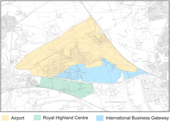
6.13b Implementation of the WEPF is now expected to come forward in two main phases, as illustrated in Figures 6.1 and 6.2. In Phase 1, airport development will take place mostly within the existing airport boundary with only modest encroachment onto land currently in RHC use. New RHC development will be located within and adjacent to its existing site on the north side of the A8 and the development of the IBG will start on the east side of Eastfield Road. Phase 2 will commence once the RHC is required to relocate to the south of the A8 to facilitate further airport expansion. Land used for RHC development in the short term, which is not required for airport expansion, will form a later phase of the IBG. Phase 2 is anticipated to come forward in 2020 at the earliest but more likely around 2030. This local plan alteration focuses on the land use allocations required to bring forward development in phase 1, with land safeguarded to the south of the A8 for the implementation of phase 2. Beyond the period of this local plan, WEPF 2008 will be implemented through future strategic and local development plans.
Figure 6.1 : Implementing WEPF 2008 : Phase 1 - Interim Scenario (pre 2020/2030)
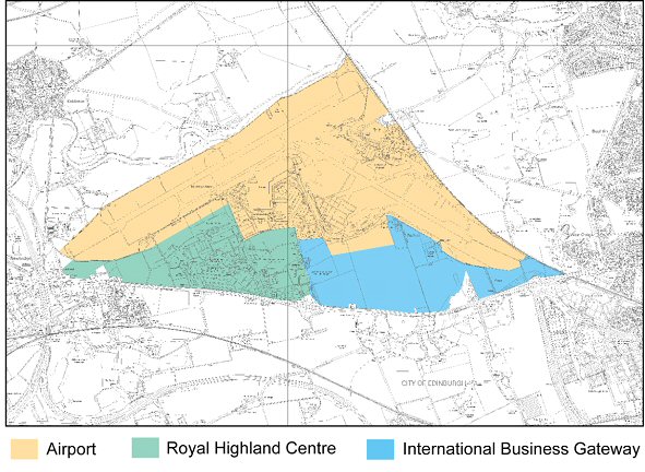
Figure 6.2 : Implementing WEPF 2008 : Phase 2 - Long Term Scenario (post 2020/2030)
Structure Plan Context
6.14 The Edinburgh and the Lothians Structure Plan 2015 introduces new and changed economic development aims and policies which directly affect Rural West Edinburgh.
6.15 Local plans are required to support the development of sites in the established economic land supply. These are sites, which are already serviced or can easily have services provided, are available for development, and in a marketable location. There are only two undeveloped sites in this category in Rural West Edinburgh: Ferrymuir Phase 2 and South Scotstoun, both of which are in Queensferry.
6.16 The Structure Plan guides business development to defined strategic centres and applies a policy of restraint elsewhere. Rural West Edinburgh is not identified as a strategic location for major new economic growth in recognition of its landscape character and existing traffic problems. However, a number of existing developments in this local plan area are of strategic economic importance.
6.17 The Structure Plan highlights the need to make special provision for the three major established green belt uses: Edinburgh Airport, the Royal Highland Showground and Heriot-Watt University's Edinburgh Campus at Riccarton. This local plan should define their respective boundaries and specify the land uses that would be appropriate within them. Any additional expansion land can be allocated if justified through masterplans approved by the Council.
6.18 Local plans can also identify small-scale business and industrial sites within or next to existing settlements in order to promote local employment opportunities.
6.19 This local plan is also required to support office development on suitable business/industrial land at Newbridge.
Local Plan Economic Development Objectives
6.20 Taking account of the national and regional context, this local plan aims to:
- consolidate the area's economic base, promote the development of long-standing proposals and minimise any adverse impacts on the environment;
- support the development and improvement of the major established green belt uses (set out in Policy ECON 4 of the ELSP) and identified economic development proposals;
- allocate the strategically important former Gogarburn Hospital site for single-user Class 4 development of national importance;
- identify small-scale business opportunities in the towns and villages in order to support more rounded, sustainable communities;
- help keep local businesses in the plan area;
- support sustainable local tourist facilities; and
- support the environmental improvement of industrial, business and tourism facilities.
Policies and Proposals
General Industry and Business Development
6.21 The take-up of business and industrial sites in Rural West Edinburgh has picked up in recent years. The local plan will help to consolidate the area's economic base and, with the exception of the nationally important Gogarburn site, which remains part of the Edinburgh Green Belt, does not propose to allocate new large sites for business and industry. The available business and industrial opportunities identified in the local plan will, therefore, be restricted to sites from the Structure Plan 'established economic land supply', sites allocated in previous local plans, and those with planning permission.
6.22 These proposals provide a balanced range of sites in terms of quality, size and location on a scale consistent with the local plan strategy. They will help provide jobs close to existing and planned homes, which in turn will reduce travel-to-work trips and help communities to become more self-sufficient. Within the existing and proposed business and industrial land supply, different sites will be suited to different uses, depending on factors such as location, environmental quality, the nature of neighbouring uses, and traffic impact. More details, including the preferred use of each site, are set out in the 'Schedule of Economic Development Proposals' at the end of this chapter, and the Council intends to produce a planning brief for land that has been included within ECON5.
6.23 In recognition of the importance of job creation and economic development to the well-being of the local plan area and the Council area as a whole, existing and proposed business and industry sites will be safeguarded for uses falling within classes 4, 5 and 6 of the Town and Country Planning (Use Classes) (Scotland) Order 1997. Other uses will not be permitted if incompatible with the primary business purpose of the area or if the loss of business or industrial land is unacceptable in terms of the amount, quality and distribution of the overall supply.
6.24 The local plan balances providing an adequate supply of marketable land for business and industry with ensuring that such development does not cause unacceptable damage to the environment. General industry, storage and distribution and large-scale Class 4 uses can generate noise and significant traffic flows and are, therefore, not acceptable in or close to housing areas. They should be directed to appropriate business and industrial sites identified in the local plan. However, it is recognised that small-scale business uses can be compatible with residential areas and can contribute to the local economy and the vitality of communities. Class 4 uses are, therefore, supported on a small- scale throughout the built-up area as a means of encouraging the development of start-up businesses.
Policy ED1 - Sites for Business and Industry
The Council will support the development of sites ECON 1 - ECON 11 for the preferred uses outlined in the Schedule of Economic Development Proposals. These sites, and areas defined as 'Existing Business Areas' on the Proposals Map, are safeguarded for business (Class 4), general industry (Class 5) or storage and distribution (Class 6) uses. Specific proposals for such uses must be compatible with the character of the site and surrounding area in terms of the nature of the proposal, its siting, layout and design and traffic and environmental impact. Other uses will only be permitted where:
- compatible with business and industrial activity; and
- there would be no significantly adverse impact on the overall amount, quality or distribution of the business and industrial land supply in the local plan area; and
- they are compatible with the character of the site and the surrounding area in terms of the nature of the use, siting, layout and design and where there would be no significantly detrimental traffic or environmental impact.
Environmental improvements will be supported in business and industrial areas. Major business and industrial development will not be permitted outside these areas.
Policy ED2 - Small-scale Business Development
Small-scale business development will be permitted in the built-up areas, as defined on the Proposals Map, provided there would be no significant adverse effects on residential amenity or the environment.
6.25 Edinburgh's economy depends on its existing wealth generating businesses and it is important that their expansion needs are met, wherever appropriate. However, it is also important to prevent proposals which would have unacceptable impacts on the environment and amenity.
Policy ED3 - Expansion of Existing Businesses
The expansion of existing businesses in situ will be supported, provided:
- the businesses are within the built-up area, as defined on the Proposals Map; and
- there would be no significantly detrimental impact on neighbouring uses and local residential amenity; and
- the scale of new development is appropriate to the size of the site and its surroundings.
6.26 Proposals for new development or the expansion of existing premises are an opportunity to improve the environmental quality of business and industrial areas in terms of landscaping, design of buildings, air quality, energy efficiency and waste management.
Policy ED4 - Quality of Business and Industrial Development
The Council will encourage business and industrial developments to incorporate best practice in terms of air quality control, the maintenance and increase of bio-diversity, efficient energy consumption and waste management. Development proposals should include details of landscaping provision, where necessary, and incorporate quality design standards appropriate to the nature of the site and the proposed use.
Major Uses in the Green Belt
6.27a Edinburgh Airport, the Royal Highland Centre and Heriot-Watts Edinburgh Campus at Riccarton are established uses of considerable economic importance currently located in the Edinburgh Green Belt. The approved Structure Plan retains these uses in the green belt whilst supporting their future development in line with approved master plans. Since the approval of the Edinburgh and the Lothians Structure Plan, the West Edinburgh Planning Framework has been reviewed. WEPF 2008 set outs a more up to date policy context for development in West Edinburgh. It also requires the Council to prepare a strategic design framework to guide future master plans and development.
6.27b The West Edinburgh Strategic Design Framework (WESDF) will play an important role in ensuring that future master plans and development proposals deliver the objectives of the WEPF. It sets out strategic design principles to promote high quality, sustainable development and includes guidance on landscape, built form, movement and infrastructure. The WESDF promotes a co-ordinated approach to development across West Edinburgh and seeks to avoid adhoc, piecemeal development. A key element of policies ED5, ED6 and ED6a is the need for proposals at the Airport, Royal Highland Centre and International Business Gateway to accord with the WESDF.
6.28 Government support for the expansion and enhancement of Edinburgh Airport is set out in WEPF 2008 and National Planning Framework 2. Based on the Edinburgh Airport Master Plan (July 2006), WEPF 2008 identifies land for airport expansion in the period 2013 -2020 and requires land to be safeguarded for a possible second main parallel runway. The operator of Edinburgh Airport currently has rights which allow certain operational uses and buildings to be developed without applying for planning permission. When considering permitted development proposals, the airport operator is encouraged to continue the practice of consulting the Council and to take account of the WESDF.
6.29a Other forms of airport-related development need planning permission. Land in and close to airports is a valuable resource that should be used to meet airport expansion requirements or related uses that have strong and direct functional and locational links with the airport. It is important that the introduction of related uses does not prejudice existing and future airport operations. Uses which are, or could be considered to be airport-related, are listed in Appendix H. Proposals should take account of the detailed criteria set out in policy ED5 and accord with the WESDF.
6.29b The timescales for airport expansion set out in WEPF 2008 are based on the Edinburgh Airport Master Plan 2006. In September 2008, BAA amended its master plan to reflect changes to the airport expansion proposals. As a result, only a small section of land currently in showground use is needed for airport development in the short/medium term. The relocation of showground uses to land to the south of the A8 will still be necessary to facilitate airport growth in the longer term (see Figure 6.2). However, this is not anticipated to happen until at least 2020 and more likely 2030, well beyond the period of this local plan.
6.29c WEPF 2008 identifies land to the north of the existing airport boundary to be safeguarded to provide a second main parallel runway, if this is required in the future, to meet air passenger forecasts. Until a decision is made that a second parallel runway is required, the safeguarded land will remain in the green belt and green belt policy will apply. The views of the airport operator will be sought to ensure that any proposals in this area would not prejudice the potential for long term airport expansion. If a second runway is developed, a number of mitigation measures will be required to maintain the water quality, flow rate and sedimentation pattern of the River Almond as it enters the Firth of Forth. These measures are to ensure that the proposal does not have a significant effect on the Firth of Forth Special Protection Area.
6.30 As indicated above, the long term expansion of Edinburgh Airport requires land currently occupied by the Royal Highland Centre. WEPF 2008 and NPF2 support the relocation of the Royal Highland Centre and its redevelopment as Scotlands National Showground on an alternative site at Norton Park on the south side of the A8. As a result of changes to airport expansion proposals, the Royal Highland Centre will continue to occupy its existing site until at least 2020 and more likely 2030. In the interim, Policy ED6 supports proposals for the development and improvement of the RHC on land within and adjacent to its existing site on the north side of the A8. Policy ED6 highlights the need for a master plan for the whole site which should accord with the principles set out in the WESDF. Land at Norton Park is safeguarded to facilitate future RHC relocation when its existing site is needed for airport expansion purposes.
6.31 WEPF 2008 and NPF2 introduce a new nationally important business opportunity in West Edinburgh, the International Business Gateway (IBG). WEPF 2008 indicates that this land should be removed from the green belt in future strategic and local development plans. In the interim, in recognition of its potential value to the national economy, IBG proposals may be approved as a justified exception to green belt policy. The main purpose of the IBG is to attract inward investment and create new jobs for Scotland. International business development may take various forms, including the development of global/European/UK headquarters and accommodation supporting high-value corporate functions for international organisations. Proposals will not be supported which involve the relocation of existing businesses from elsewhere in Scotland. A legal agreement may be required to ensure that business premises are occupied by international organisations both at the outset and in the longer term. WEPF 2008 also identifies ancillary uses which will be acceptable in the IBG. These will play an important role in meeting the place-making objectives set out in the WESDF. Policy ED6a requires proposals for the IBG to be consistent with the WESDF and accord with an approved master plan.
6.32 The Edinburgh Campus at Riccarton comprises Heriot-Watt University and its research park. A masterplan for the whole campus was approved by the Council as supplementary planning guidance in January 2001. It provides an integrated land use and transportation framework to guide the growth of the campus. The masterplan allows for the further expansion of the research park for research and development uses which have strong links to the University's academic work. Expansion of the university itself is also included, with areas allocated for new student accommodation and new Northern and Southern campuses. Some of the land currently used as playing fields will be built on, but grassed pitches of at least equivalent quantity and quality will be provided on land to the south of the existing campus boundary, maintaining a green buffer between the campus and the railway. The new playing fields will be phased with the development of the Southern Campus to ensure that continuity of provision is maintained at all times. A summarised masterplan diagram is included for illustrative purposes in Appendix I but the approved masterplan itself will be the basis for development control decisions.
6.33 As with the Airport and Showground, when considering proposed development within the campus, careful consideration will be given to the nature of the use, scale and location, accessibility by public transport, access arrangements, levels of traffic generation, screening and landscaping, and habitat protection and enhancement to ensure that development proposals do not undermine green belt objectives and overall sustainable development aims.
Policy ED5 - Edinburgh Airport
Proposals within the Airport Boundary
Proposals for the development and enhancement of Edinburgh Airport will be supported within the airport boundary defined on the Proposals Map, where consistent with an agreed Edinburgh Airport Master Plan. Other airport-related uses will only be permitted where it can be demonstrated that these have strong and direct functional and locational links with the airport and are compatible with the operational requirements of the airport and other relevant Council policies.
All development proposals within the airport boundary should accord with the West Edinburgh Strategic Design Framework and be acceptable in terms of:
- scale and location;
- accessibility by public transport, pedestrians and cyclists; Supporting information will be required to demonstrate how proposals will contribute to meeting the modal share targets set out in the WESDF.
- traffic generation and car parking;
- landscaping;
- sustainable building;
- drainage and flood management;
- habitat protection and enhancement;
- place-making and design; and
- impact on setting and views, including wider townscape impacts.
Long Term Safeguard
Land to the north of the existing airport boundary is safeguarded to provide a second main parallel runway, if required in the future, to meet air passenger growth forecasts. Within this area, green belt policy will apply (policies E5 and E6). Proposals which would prejudice the long-term expansion of Edinburgh Airport will not be supported.
Policy ED6 - The Royal Highland Centre
Proposals within the Royal Highland Centre Boundary
Proposals for the further development and enhancement of the Royal Highland Centre will be supported within the boundary defined on the Proposals Map. Related uses will only be permitted where it can be demonstrated that these have strong and direct functional links with the primary purpose of the RHC.
Proposals must accord with the West Edinburgh Strategic Design Framework and be consistent with an approved master plan. Proposals should be acceptable in terms of :
- scale and location;
- accessibility by public transport, pedestrians and cyclists; Supporting information will be required to demonstrate how proposals will contribute to meeting the modal share targets set out in the WESDF.
- traffic generation and car parking;
- landscaping;
- sustainable building;
- habitat protection and enhancement;
- place-making and design; and
- impact on setting and views, including wider townscape impacts.
Long Term Safeguard
Land at Norton Park as shown on the Proposals Map is safeguarded for the future relocation of the RHC and its development as Scotlands National Showground. Within this area, green belt policy will apply (policies E5 and E6). Proposals which would prejudice the future development of the Norton Park site for showground purposes will not be permitted.
Policy ED6a - International Business Gateway
In recognition of its importance to the national economy, proposals for the development of an International Business Gateway within the boundaries defined on the Proposals Map will be supported. The following uses are supported in principle:
- International business development (as described in paragraph 6.31);
- Hotel and conference facilities;
- Uses ancillary to international business development, such as child nursery facilities, restaurants and health and sports clubs.
All IBG proposals must accord with the West Edinburgh Strategic Design Framework and be consistent with an approved master plan. Proposals should be acceptable in terms of:
- scale and location;
- accessibility by public transport, pedestrians and cyclists; Supporting information will be required to demonstrate how proposals will contribute to meeting the modal share targets set out in the WESDF.
- traffic generation and car parking;
- open space and landscaping;
- sustainable building;
- drainage and flood management;
- habitat protection and enhancement;
- place-making and design; and
- impact on setting and views, including wider townscape impacts.
Policy ED7 - Heriot-Watt University's Edinburgh Campus at Riccarton
- Development for the following purposes will be supported within the boundary of the Riccarton Campus, as defined on the Proposals Map, provided proposals accord with the approved campus masterplan:
- Academic teaching and research;
- Facilities ancillary to the University, including student residential accommodation and sport and recreational facilities; or
- Research and development of products or processes. Acceptable development activities in this category include the production of prototypes but not the production or manufacture of goods on a scale intended for commercial distribution to the general market. Occupiers will also be required to demonstrate direct functional linkages with the University's academic activities. Prior to issuing any consents, applicants will need to enter into a Section 75 agreement with the Council to ensure proposed developments conform to these requirements.
- Within the overall Campus boundary, proposals will be required to be acceptable in terms of:
- scale and location;
- public transport accessibility;
- access arrangements, junction capacities and levels of traffic generation;
- high quality screening and landscaping;
- habitat protection and enhancement;
- impact on green belt objectives and neighbouring uses; and
- retaining the amount and quality of playing field provision, in accordance with Policy E51.
- Uses which do not conform to the approved masterplan will only be permitted where it can be demonstrated that they have clear and strong functional links to the University. The campus uses set out in part (A) will not be permitted outside the defined boundary of Riccarton Campus where normal green belt policy will apply.
Consultation Zones
6.34 There are installations which store hazardous substances to the west of Queensferry and the south of Dalmeny. These, together with the high pressure gas pipelines which run through the plan area, are a potential public safety hazard. The Council has a statutory duty to consult the Health and Safety Executive (HSE) on planning applications which involve a notifiable substance. Within defined Consultation Zones, all planning applications will be referred to the HSE. The zones highlight an area of greater potential risk and, therefore, careful consideration must be given to the safety implications of development proposals. Housing and other uses involving significant numbers of people will generally be unacceptable in these zones, unless it can be clearly shown that there would be no significant threat.
Policy ED8 - Hazard Consultation Zones
The Council will have regard to the advice of the Health and Safety Executive (HSE) on the suitability of any proposal for a new notifiable installation and will consult them concerning any development proposal in the Hazard Consultation Zones identified on the Proposals Map.
6.35 There are two types of national safety designations at Edinburgh Airport: Public Safety Zones (PSZs) and Aerodrome Safeguarding. PSZs are defined by the Department of Transport, based on risk appraisal modelling. The zones extend from both ends of Edinburgh Airport's main runway and are shown on the Proposals Map. In these zones special development restrictions apply to control the number of people on the ground at risk of death or injury in the event of an aircraft accident on take-off or landing.
6.36 The CAA is no longer involved in PSZ administration and it is now for planning authorities to decide applications and consider road proposals in these zones. A Scottish Executive Circular sets out detailed assessment criteria.
Policy ED9 - Edinburgh Airport Public Safety Zones
Development will not be permitted within the Airport Public Safety Zones, as defined on the Proposals Map. This includes new or replacement dwellinghouses, mobile homes, caravan sites or other residential buildings. Depending on the circumstances of individual proposals, the following types of development may be permitted as an exception to this general policy:
- extensions and changes of use; or
- new or replacement development which would be associated with a low density of people living, working or congregating.
In assessing applications, the Council will take account of the detailed guidance and assessment criteria in SEDD Circular 8/2002: Control of Development in Public Safety Zones. Before granting planning permission for developments in the PSZs, the Council will consult the Civil Aviation Division in the Department of Transport and take its views into account.
Aerodrome Safeguarding
6.37 Edinburgh Airport is an officially safeguarded civil aerodrome. Land within a considerable radius of the airport lies in a CAA-defined safeguarded area within which the purpose is to control the height and design of development to protect aircraft flying surfaces, keep runway lights clear, protect other navigational aids and reduce the risk of a birdstrike hazard from landscaping, water bodies and other features.
6.38 A copy of the official safeguarding map is held by the Council. Colour coded height consultation areas extend across the whole of the plan area. The birdstrike and aviation uses consultation zone is defined as the land within a 13 km radius of the airport, covering the whole plan area with the exception of a small area of land in the Pentland Hills, as shown on the Proposals Map. Wind turbine proposals in particular have to be carefully assessed for their potential affect on radar systems and aircraft navigation.
6.39 The airport operator must be consulted, as appropriate, on proposals for:
- wind turbines (whole plan area);
- development which would exceed height limits (varies across plan area from all proposals to those over certain heights);
- aviation uses and development that could constitute an unacceptable birdstrike hazard (13km radius from airport).
If the Council is minded to grant planning permission contrary to the operator's advice, proposals are automatically notified to the CAA.
Policy ED10 - Airport Safeguarding
Within the whole local plan area, the height and detailed design of buildings, including wind turbines, will be controlled to ensure airport operations and aircraft movements are not inhibited, in line with the requirements of The Town and Country Planning (Safeguarded Aerodromes, Technical Sites and Military Explosives Storage Areas) (Scotland) Direction 2003. Development which would create or increase the risk of an unacceptable birdstrike hazard within the defined consultation area will not be permitted. The operator of Edinburgh Airport will be consulted on relevant planning applications in this area and the Council will take its views into account.
Tourism
6.40 Tourism makes an important contribution to the local economy in terms of job creation and revenue generation. The development and improvement of tourism facilities in the local plan area is, therefore, encouraged. The places with the greatest potential for further development as tourism destinations are likely to be Queensferry, the Union Canal at Ratho, the Water of Leith and the Pentland Hills. There is an opportunity for a visitor centre/ bridges interpretation centre in Queensferry. The historic Hawes Inn area and the Forth Road Bridge car park are locations where such a facility could be supported in principle, subject to detailed assessments.
6.41 To be sustainable and help reduce energy consumption, tourist proposals should maximise their accessibility to public transport connections and cycle routes. They should not have a detrimental impact on the rural landscape, features of urban and nature conservation value, local residential amenity or the surrounding road network.
6.42 Given the potential for more tourist attractions in Rural West Edinburgh, there is likely to be an accompanying growth in demand for tourist accommodation in the area, including proposals for hotels and guest houses, self-catering accommodation and caravan and camping facilities. The Town and Country Planning (Use Classes) (Scotland) Order 1997 permits the use of a dwellinghouse as a guest house or bed and breakfast, provided no more than two bedrooms (or one bedroom for houses with less than four bedrooms) are used by paying guests. Proposals involving a flatted property, or a house where more than the permitted number of bedrooms will be used by guests, will require planning permission. Guest houses can have a detrimental impact on residential amenity and the character of an area, as a result of advertising, evening activity and additional parking. In the interests of amenity, to limit losses from the housing stock and to best meet the needs of tourists, guest house uses should be restricted to the main tourist areas and routes. It is unlikely that a flatted property could be used as a guest house without causing disturbance to neighbouring residents.
6.43 Proposals for the development of hotels, travel lodges, self-catering accommodation, and mobile caravan, camping and chalet sites will be assessed in relation to Policy ED11. Policy E24 in the Environment chapter offers additional guidance on caravan and camping development in the Green Belt and countryside. Proposals for the change of use of buildings in the countryside or Green Belt for tourism purposes should also comply with the provisions of Policy E5 and Policy E6 in the Environment chapter (Chap. 3). In 2007, a consultants study West Edinburgh Visitor Accommodation Analysis concluded that the area around Edinburgh Airport has an under provision of directly associated hotel capacity. In order to increase provision, hotel development will be supported as an exception to green belt policy provided proposals come forward as an integral element of master plans for the Airport, Royal Highland Centre and the International Business Gateway and accord with the West Edinburgh Strategic Design Framework.
6.44 Policy ED12 restricts guest house uses to: established areas on Lanark Road and Lanark Road West in Currie, part of Balerno; The Loan, High Street and Hopetoun Road in Queensferry; Main Street and Baird Road, Ratho. In the case of Lanark Road and Lanark Road West, proposals for guesthouses in the immediate vicinity of the main road (i.e. within 80 -100 metres of the junction and reasonably visible from the main road) will also be considered.
Policy ED11 - Tourist and Visitor Facilities
Proposals for new or improved visitor and tourist facilities will be supported, provided:
- they are well-located in relation to the public transport network;
- there would be no significant adverse effect on residential amenity, the landscape or important built or natural heritage features;
- they are located within the built-up areas defined on the Proposals Map or would result in the appropriate reuse of a rural building;
- they would deliver clear community benefits; and
- the scale of development and anticipated visitor numbers are compatible with local environmental character and the capacity of the road network.
Within the boundaries of Edinburgh Airport, the Royal Highland Centre and the International Business Gateway, hotel development will be supported provided proposals accord with the West Edinburgh Strategic Design Framework and are consistent with an approved Master Plan.
Policy ED12 - Guest Houses
The change of use of a dwelling house to a hotel or guest house will be permitted in the 'Guest House Areas' as defined on the Proposals Map, provided there would be no significantly adverse impact on residential amenity or the residential character of the area. The use of a flat as a guest house will not be permitted.
| Reference | Location | Area (Hectares) | Ownership Use | Proposed Use |
|---|---|---|---|---|
| View ECON1 on map | South Scotstoun, Queensferry | 3.5 | Private | Class 4 |
| View ECON2 on map | Ferrymuir, Queensferry | 3.3 | Private | Class 4 excluding any industrial process |
| View ECON3 on map | Clifton, Newbridge | 7.2 | Private | Class 4, 5 or 6 |
| View ECON4 on map | Cliftonhall Road, West Newbridge | 2.3 | Private | Class 4, 5 or 6 |
| View ECON5 on map | Claylands, Newbridge South | 31.1 | CEC | Class 4, 5 or 6 |
| View ECON6 on map | Cliftonhall Road, South Newbridge | 0.9 | CEC | Class 4, 5 or 6 |
| View ECON7 on map | Newbridge North | 22.2 | Private | Class 4 |
| View ECON9 on map | Gogarburn | 36.3 | Private | Single-user Class 4 |
| View ECON10/HSG7 on map | Port Edgar, Queensferry | 7.9 | CEC | Class 4 marina uses, marine businesses and housing |
Briefs
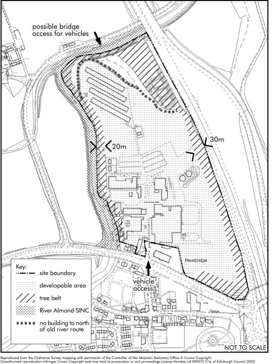
ECON 7 - Newbridge North (Former Grampian Foods Site)
- Site Areas: 22.2 Hectares
- Ownership: Private
- Proposed Use: Class 4 uses.
The site was formerly occupied by a poultry rearing and processing business. The site boundaries are formed by the M9 to the east, the A89 Edinburgh to Broxburn Road and Newbridge Industrial Estate to the south and the River Almond to the north and west. Edinburgh Airport runway lies nearby to the north east.
The existing industrial buildings are intrusive in the landscape and highly visible from the M9, which forms one of the major gateways into the city. The relocation of the existing operation is an opportunity to provide a high quality modern, low density business park within a landscaped setting, designed to complement the site's gateway status.
Background
On 6 February 2002, a report was approved recommending that consent be granted for development as a business park with ancillary uses, subject to a Section 75 agreement being concluded between the applicant and the Council. The consent was also subject to a number of reserved matters, namely the preparation of a masterplan which would provide details of site layout, access, height and massing of buildings, materials and pedestrian and cycle links through the site and beyond.
Essential Features
A landscape plan should direct development of the site and a management plan for the area of the River Almond Site of Interest for Nature Conservation (SINC) will also be required. No development shall be permitted within 20m of the SINC. A further 30m belt of planting will be needed along the M9 boundary to the east to screen the site and provide a parkland setting to the development.
No building will be permitted to the north of the old river route. The existing woodland should be kept and the area between it and the former river should be wooded. The development should be clearly set in a rural context and the masterplan should reflect a woodland setting with heights no more than three storeys. The public safety zone and height restrictions associated with the airport's main runway affects part of the site and will need to be taken into account in the masterplan. A robust internal landscape framework to merge with perimeter planting and address visual issues, for example car parks, will be required.
Access to the site should be from the A89 to the south. A further possible bridge link over the River Almond to the north is a possibility which would give a direct route through the development. However, if a bridge is to be included, developers must demonstrate that the SINC is adequately safeguarded. Prior to the occupation of the site, a Green Travel Plan and detailed improvements to the road infrastructure will be required.
The scheme should include overground Sustainable Urban Drainage (SUDS) measures where required, in line with Council policy. Part of the development site requires ground levels to be raised above 1 in 200 year flood levels. As a result, the development must include flood storage areas in line with approved Council policy.
Prior to any development taking place, a programme of archaeological trial excavations shall be approved by the Council's archaeologist and carried out to establish the extent of any remains associated with Huly Hill.
The existing consent does not include the houses and the car showroom that lie on the southern boundary formed by the A89.
Given the site's rural location and prominence from an aerial approach to the city, it is recommended that green roofs are incorporated in the design of the buildings and car parks.
The plan shows the development sites, the main constraints affecting the site and the access point.
ECON 7 - Newbridge North (Former Grampian Foods Site)