Chapter 7: Transport
Background
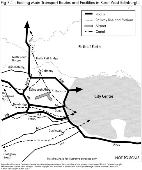
7.1 The Rural West Edinburgh Local Plan area is a key location in the transport network of east central Scotland. Four passenger railway lines pass through it as do a number of major roads, all of which provide strategic links between the city and the west and north of Scotland and beyond (see Figure 7.1). A network of local roads supplement the major roads in linking the settlements located in Rural West Edinburgh and providing access from these settlements to the city. Edinburgh Airport is also in the area.
7.2 The local transport network is strongly focused on radial routes into Edinburgh, with poorer north and south links. There are several off-road cycle routes, some of which form sections of the National Cycle Network. Provision is made for pedestrians through both on and off-road footpaths.
7.3 Because of its strategic location, Rural West Edinburgh faces transport issues and problems inseparable from those of urban Edinburgh and central Scotland as a whole. Road traffic in the local plan area has been growing at a rate which is faster than the average for Scotland. Previous transport initiatives in Rural West Edinburgh have helped deal with increasing traffic through new road schemes such as the 'City Bypass', the 'M8 Extension' and the 'Newbridge Underpass'. Traffic management schemes have been introduced in some settlements, for example, in Balerno and Kirkliston, in order to reduce the impact of through traffic on environmental quality and residential amenity.
7.4 It is now widely recognised that constructing new roads to accommodate a continued rise in private car use is unsustainable. There is increasing awareness of the need for alternative policies to tackle the growth in car use and reduce associated environmental, safety, economic, health and social impacts. In response to the above, in October 2000, the Council adopted the 'on route' Local Transport Strategy which seeks to reduce car dependency, promote high quality public transport and encourage people to walk and cycle. As well as tackling the growth in car use, the LTS also has an important role in meeting the travel needs of people without access to a car. The challenge in Rural West Edinburgh, as elsewhere, is to maximise the potential for journeys to be made by bus, foot and cycle. The more dispersed settlement pattern of the area makes this more problematic than within urban Edinburgh. In addition, there is a need to improve public transport linkages between the main urban area of Edinburgh and major traffic generators in the local plan area, such as Edinburgh Airport and the Royal Highland Showground.
7.5 The number of passengers using Edinburgh Airport has increased above the U.K. average in recent years, a trend which is expected to continue. Work has been completed on a major extension of the airport terminal building to meet the needs of the increased passenger traffic. The airport also accommodates a thriving cargo business, linked to its customs facility. With the expansion of passenger traffic, the airport has acquired redundant land and property at R.A.F. Turnhouse, which has been earmarked for cargo-based airport development. In addition, in August 2002, the Department for Transport published a consultation document called 'The Future Development of Air Transport in the United Kingdom: Scotland'. This document looks at the future of air services and airports in Scotland and across the U.K. as a whole. Various options have been suggested for the expansion of Edinburgh Airport, a number of which include the provision of a second main runway. The Government published a White Paper called 'The Future of Air Transport' (PDF,1.8MB) at the end of 2003. See paragraph 6.12 of the Economic Development and Tourism chapter.
7.6 Water-based travel along the Union Canal is likely to increase in popularity as a result of the implementation of the Millennium Link project which reopened the canal link between Edinburgh and Glasgow in 2002.
National Context
7.7 In July 1998 the Government published 'New Deal for Transport' and issued two transport white papers, one for the U.K. and one for Scotland. These were the first major government policy statements to be published on transport since 1975. Their approach recognised the need to reduce dependence on the private car and improve the alternatives. Both papers contained a wide range of proposals with considerable implications for transport at local and national levels. Local authorities were invited to prepare local transport strategies to take forward the principles set out in the transport white papers.
7.8 Following the publication of the transport white papers, the Government issued NPPG 17 and PAN 57 on transport and planning in April 1999. The NPPG sets out guidance on how the Government's policies for the integration of transport and land use planning should be reflected in the operation of the planning system and indicates the range of considerations to be addressed when assessing development proposals which may have an impact on transport policy and provision. It outlines a number of transport planning principles aimed at reducing the need to travel, especially by car, which should be incorporated into development plans. Until development plans are reviewed, these principles should be material considerations in the exercise of development control. The PAN provides guidance on the implementation of the NPPG and offers advice on good practice in transport planning.
7.9 The U.K. National Air Quality Strategy established by the Environment Act 1995 sets out government policy for improving air quality, including targets to be met by 2005. Local authorities now have a duty to review and assess air quality and prepare 'action plans' for areas where there is an air quality problem. Vehicle emissions contribute directly to poor air quality and recent indicators show that pollution from households is also a significant factor. The 'Road Traffic Reduction Act 1997' seeks to reduce vehicle emissions through a strategy designed to reduce the amount of vehicular traffic on the roads.
7.10 For some years, the issue of future transport links across the Forth has been debated by the Scottish Executive and other interested parties. The discussions have involved various options, including the possible construction of a second road bridge at Queensferry, with associated road links, and improvements to both rail and road-based public transport services. However, the Scottish Executive decided to defer its decision on whether or not to proceed with a second crossing of the Forth at Queensferry and instead, in December 2002, announced its intention to establish a second crossing at Kincardine. At this time there is no requirement to safeguard any possible routes either for a bridge or for the approach roads at Queensferry, but it should be noted that this option has not been formally abandoned by the Scottish Executive.
7.11a The Strategic Transport Projects Review (STPR) identifies interventions to be delivered, designed or developed beyond 2012 and primarily between 2012 and 2022. Projects most relevant to the Rural West Edinburgh Local Plan area are as follows:
- Strategic road safety plan
- Maintenance and safe operation of Scotlands rail network
- Integrated ticketing
- Forth Replacement Crossing
- Edinburgh to Glasgow rail improvements
- Park and Ride and Park and Choose expansion/rebranding at Ingliston
- Bus based light rapid transit connections between Fife and Edinburgh.
- East of Scotland rail improvements
- Targeted road congestion/environmental relief schemes (includes A720)
- Intelligent transport systems (includes A720)
A number of other measures will also have positive implications for the area, including projects aimed at increasing the frequency of rail services and reducing journey times.
7.11b The West Edinburgh Planning Framework (WEPF 2008) sets out a long term vision for West Edinburgh and recognises the importance of sustainable transport infrastructure as an integral component of development proposals. It includes committed transport proposals, i.e. the Edinburgh Tram from Newhaven to Edinburgh Airport (under construction), a rail station in the Gogar area with associated tram interchange and the construction of a Dalmeny Chord rail link between the Glasgow and Fife lines. Beyond that, WEPF 2008 states that strategic transport interventions are to be subject to ongoing appraisal and decisions will be made through the development plan process. It required the Council, together with key stakeholders, to undertake an appraisal of transport options for West Edinburgh, taking into account development, accessibility, environmental and implementation objectives and other proposed changes to the strategic transport network in the area. The transport appraisal work has been undertaken and its outcomes used to inform this local plan alteration.
7.11c The West Edinburgh Transport Appraisal (WETA) was carried out in accordance with Scottish Transport Appraisal Guidance (STAG). The aim of the study was to appraise alternative approaches to tackling the transport accessibility requirements of the WEPF in order to assist the Council in deciding which package of policies and interventions to bring forward in conjunction with future development in West Edinburgh. WETA has taken account of development, accessibility, environmental and implementation objectives and other proposed improvements to the strategic transport network in the area. It looked at transport requirements in conjunction with both the interim and long term phases of development in West Edinburgh (Figures 6.1 and 6.2). Informed by the outcomes of WETA, the Final Report of which was published in February 2010, a package of transport, a proposed package of transport measures has been identified and those with land use implications are identified as local plan proposals.
Regional Context
7.12 The Edinburgh and the Lothians Structure Plan strategy, with the exception of the Newbridge/Kirkliston/Ratho core development area, identifies west Edinburgh as an area of restraint because of its green belt designation, its high quality landscapes, environmental objectives and existing traffic problems. The Structure Plan transport strategy is an integrated package of measures which complements the land use strategy. It aims to:
- ensure that the location and design of new development, especially major new development, reduces the need to travel by car and encourages the use of public transport, walking and cycling;
- maximise accessibility for all in the community by foot, cycle and public transport;
- manage car use through parking policies, particularly by applying development control parking standards in conjunction with public transport improvements;
- encourage the movement of freight by rail, sea and, where road freight is dominant, along the strategic road network;
- support transport strategies by safeguarding land for improvements to transport networks and prioritising the provision of new transport infrastructure required to support the development strategy; and
- ensure that new development caters for its transport needs.
7.13 The Council's 'on route' Local Transport Strategy sets out an overall vision for Edinburgh's transport for the next 20 years and details the Council's policies and proposals for transport in and around Edinburgh in the period to 2004.These objectives are reflected in the transport section of the Structure Plan. The LTS sets out two alternative strategies, a 'base' strategy which assumes continuing with existing sources of funding, and a 'preferred' strategy involving an 'Integrated Transport Initiative'. The Integrated Transport Initiative would see the introduction of congestion charging, which would directly reduce congestion in Edinburgh as well as providing funding for a significantly expanded transport investment package. In either the base or preferred case, Edinburgh is likely to see major new transport investment over the period to 2010. Key investments will include new park & ride sites at Hermiston and Ingliston, a tram route to the Airport and Newbridge and possibly a direct rail link to the Airport.
7.14 The traffic pressures in Rural West Edinburgh make it of strategic transport importance and the Structure Plan, therefore, includes a number of proposals to improve public transport in the area. The most significant of these is the West Edinburgh Tram. Other proposals include the provision of park & ride facilities, improved rail infrastructure and services and traffic management measures.
Local Plan Objectives
7.15 This local plan seeks to achieve the relevant elements of the Council's transport strategy in the Rural West Edinburgh area. The objectives are:
- to reduce reliance and use of the private car and maximise accessibility for all, through careful location and design of new development and the provision of dedicated infrastructure to encourage walking, cycling and public transport use;
- to improve road safety and enhance the quality of the environment, particularly for pedestrians and cyclists through the introduction of appropriate traffic management measures and provision of dedicated infrastructure;
- to improve public transport linkages between the city and the major traffic generators in Rural West Edinburgh;
- to encourage the movement of freight by rail, wherever possible;
- to safeguard land for new transport infrastructure where this can be fully justified in strategic terms, while ensuring that adverse environmental impacts will be minimised.
Policies and Proposals
Location and Design of Development
7.16 The location of development can make a significant contribution to the local plan objectives of reducing reliance on use of the private car and maximising accessibility for all. Developments can vary greatly in terms of the intensity of personal travel and the volume and nature of freight traffic generated. For example, office and retail uses are high generators of personal travel,housing generates lower levels, and warehousing results in limited personal travel. Conversely, warehousing generates a lot of freight traffic, whereas housing generates very little. The local transport strategy framework informs decisions on the location of development, based on an assessment of relative levels of accessibility.
7.17 Development proposals which generate significant levels of personal travel should be located on sites which minimise the need to travel and are easily accessible on foot, by cycle and by existing or planned, regular and frequent public transport services. Development proposals which rely solely on the private car for access are contrary to national, strategic and local transport objectives.
7.18 The Council will seek to ensure that all significant developments are accessible by foot, cycle and public transport as well as private vehicle but it is recognised that this may not be possible for some developments, particularly in the more remote parts of Rural West Edinburgh. In these cases, it may be that other planning considerations, such as the benefits achieved by the restoration of redundant traditional buildings in the countryside, for an appropriate alternative use, may outweigh any accessibility disbenefit.
7.19 Developments such as mineral and waste management operations and warehousing uses result in limited personal travel and, therefore, accessibility by foot, cycle and public transport is less important. However, such uses will generate significant levels of freight movements as a result of the transportation of goods and materials. Where possible, such uses should be well located in relation to the rail network and any future waste transfer facilities. It is recognised that, in some instances, accessibility by rail may not be a feasible option or there may be other planning considerations to be taken into account which outweigh the need for rail accessibility.
Policy TRA1 - Accessibility of Development
Development proposals with the potential to generate significant levels of personal travel should be located on sites which minimise the need to travel and are easily accessible on foot, by cycle and by existing or planned regular and frequent public transport services. Any such proposals which result in development, which is only readily accessible by private car and would have no reasonable prospect of being served by public transport, will not be permitted.
Development proposals which would generate significant levels of freight transport will be supported on sites which allow the use of rail for the movement of goods and materials.
The Council will consider exceptions to this policy only where there are specific operational or planning reasons why the terms of the policy cannot be met or are not appropriate, or where there are overall planning benefits to be gained.
7.20 The effect of significant development proposals on the road network, public transport services and cycling facilities can only effectively be assessed through 'transport assessments'. In some instances, it may be possible to identify remedial measures which would let the Council approve an otherwise unacceptable development proposal. Such measures should enable the objectives and targets of the Structure Plan and the Council's Local Transport Strategy relevant to the proposed development to be met and could include green travel plans for staff, traffic management measures, public transport improvements or providing or improving links to the development for cyclists, pedestrians and people with disabilities. The costs of providing such measures would be met by the developer and, where necessary, secured through a Section 75 or other legal agreement. Where a series of developments will have significant interacting effects, the Council may require that any transport assessment and mitigating measures consider and relate to all relevant development. The Council may also require developer contributions to strategic projects with wider benefits which, if implemented, will mitigate the impacts of relevant development. In particular, contributions will be negotiated in line with the Council's development quality guideline on tram contributions and will be subject to the provisions contained within the guideline.
7.21 A 'green travel plan' is a tool for an organisation to manage its transport needs in a way which minimises environmental impact, maximises efficiency and benefits employee health. It should reflect the individual characteristics of different sites and their occupiers. The principal objective of green travel plans is to minimise reliance on the private car by employees and visitors/customers or road based freight transportation. In order to assess whether a proposal is acceptable in terms of meeting sustainable transport objectives, the Council may require the preparation of a green travel plan alongside a transport assessment in respect of large development proposals. Green travel plans produced as part of the development control process will be expected to:
- address all significant journey types to any sites which are the subject of development proposals;
- set targets for travel related to the site which are consistent with the Council's transport strategy;
- identify the means by which any targets will be met, to the satisfaction of the Council.
7.22 The Council recognises that many trips will be made by car to access development in Rural West Edinburgh. It is, therefore, important that in assessing development proposals, consideration is given to traffic implications in terms of road capacity, air quality, road safety and the amenity of local residents. Such considerations are also relevant in relation to proposals involving freight transport.
7.23 It is important that consideration is given to the future traffic generation implications of a proposal and not just to the impact when a development is built. In assessing whether a proposal would have an unacceptable impact on the capacity of the existing road network, the Council will require to be satisfied that there would be no reasonably foreseeable problems within 15 years of the opening date of the development. In addition, prospective developers will be required to prove that the proposal will not compromise the ability of the road network to accommodate proposals in approved development plans. Part IV of the Environment Act 1995 requires planning authorities to have regard to local air quality when exercising their planning, transport and pollution control responsibilities.
Policy TRA2 - Transport Impact of Development Proposals
Development will not be permitted where it would:
- have a significant adverse impact on the ability of the existing road network to accommodate traffic unrelated to the development;
- have a significant adverse impact on public transport operations in the surrounding area;
- have an unacceptable impact in terms of air quality; or
- have a significant adverse impact detrimental to road safety, residential amenity and walking/cycling.
Policy TRA3 - Transport Impact of Development Proposals
A Transport Assessment will normally be required for significant development proposals in order to;
- assess the transport implications for access by non- car modes and proposals to improve access;
- assess the effects on the existing road network and travel system and measures to overcome these; which will include
- an analysis of access for people with disabilities and proposals to ensure such access is achieved.
Where appropriate, the Council will seek developer contributions by means of a Section 75 or other legal agreement, to secure any transport measures necessary to make a proposal acceptable. Developments likely to generate a significant amount of travel to work will be required to prepare, implement and maintain a green travel plan.
7.24 The Local Transport Strategy has the following objectives for parking provision:
- to support activity and development in locations which favour the use of sustainable means of transport, especially by managing parking in these locations to ensure adequate short stay parking provision;
- to minimise the traffic and parking impacts of new development on neighbouring areas;
- to minimise the surface area taken by parking, particularly in locations where space for other purposes is in high demand;
- to minimise the incentive to travel by car, particularly in areas where the direct adverse impacts of car use are most severe.
In February 2002 the Scottish Executive issued Draft NPPG 17 Addendum: 'Transport and Planning Maximum Parking Standards'. This now requires councils to prepare their own set of maximum parking standards and to publish them in their local transport strategies. In the past, parking standards for most developments typically set lower limits on parking provision. The effect of these lower limits was to allow parking provision at levels that provided for, and to an extent encouraged, high levels of car use. The general approach adopted in the Council's current standards is to specify ranges of acceptable provision. These set an upper as well as lower limit on parking provision for a particular development. The degree of restriction on parking provision is related to accessibility by public transport and other alternatives to the car. Financial contributions by developers towards projects aimed at encouraging increased use of public transport, walking and cycling, or otherwise reducing the amount of car travel, may be required as an alternative to providing car parking spaces.
7.25 To encourage walking and cycling, development proposals should provide for the safe movement of pedestrians and cyclists, both within the site and in relation to links to existing cycle routes and footpaths. Car parking, if poorly designed or located, can have a detrimental visual impact on the environment and residential amenity. The appropriate levels of car and cycle parking provision that should be made are established in the Council's parking standards applied throughout the Council area. The Council's car parking standards are an integral component of its transport strategy. The standards are necessarily detailed and will be subject to monitoring and possible revision. They are, therefore, published in separate supplementary planning guidance.
Policy TRA4 - Provision for Pedestrians, Cyclists and Car Parking in Development Proposals
Development proposals should make specific provision for the needs of cyclists and pedestrians and provide convenient and safe access to existing or proposed cycle and footpath networks, where practicable. Provision for car and cycle parking should be made in all development proposals in conformity with the Council's approved standards. Car parking should be sited and designed to minimise impact on visual and residential amenity and take community safety into account.
Traffic Management
7.26 Traffic management measures have been introduced in Rural West Edinburgh to keep traffic moving safely and efficiently, giving priority, where possible, to public transport, pedestrians and cyclists. The term 'traffic management measures' covers a wide range of schemes, including traffic calming, bus priority lanes, pedestrian crossing facilities, car parking provision, and directional signing, amongst others. Throughout the local plan area, the Council will support appropriate traffic management measures, in particular, in order to improve road safety, discourage through-traffic and improve the quality of the environment for pedestrians and cyclists. Developers will be expected to place greater emphasis on traffic calming and road safety in new development proposals. Traffic management measures should not impede the movement of cyclists, public transport vehicles or the emergency services. In addition, it is important that traffic management proposals are not undertaken at the expense of environmental quality. To assist in this, the Council has adopted the 'Edinburgh Streetscape Manual' which includes a methodology and recommendations on good design practice. Where it is appropriate, given the significance of a traffic management scheme, the views of the general public, businesses, service providers and the wider community will be considered.
Policy TRA5 - Traffic Management
The Council will support traffic management measures which seek to create a safe and attractive environment, particularly in town and village centres and residential areas. In these areas, through traffic will be discouraged. Developers must give emphasis to traffic calming and road safety. Proposals should incorporate high design standards and use good quality materials. The needs of pedestrians, cyclists and people with mobility difficulties, and the impact of proposals on public transport and emergency services, should be specifically addressed.
Cycling and Walking
7.27 The promotion of walking and cycling as the most sustainable form of transport, is one of the key objectives of the Council's transport strategy. Existing footpaths and cycle routes should, therefore, be protected and, where possible, enhanced.
7.28 In addition, the Structure Plan identifies former rail alignments as representing a valuable asset, because of their potential for renewed use for rail transport. Former railway lines will, therefore, be safeguarded in recognition of their potential for future cycle and pedestrian routes. The Council supports the creation of a strategic network of routes and will seek to identify opportunities to complete such a network (see Policy E26).
Policy TRA6 - Routes for Cyclists and Pedestrians
The Council will support the development of a comprehensive network of cycle and pedestrian routes, including on-road provision and off-road cycleways and footpaths. Existing routes and former railway lines will be safeguarded to protect the potential for a return to rail use, including the construction of stations and accesses, as well as reuse as walkways/cycleways. Proposals to complete missing links in key routes will be supported.
Public Transport
7.29 National, strategic and local transport policies give high priority to improving the level and quality of public transport services and facilities in order to increase their use. The Structure Plan promotes a number of significant public transport proposals in Rural West Edinburgh. These are outlined in detail in Policy TRA 8 and the 'Schedule of Transport Proposals' at the end of this chapter.
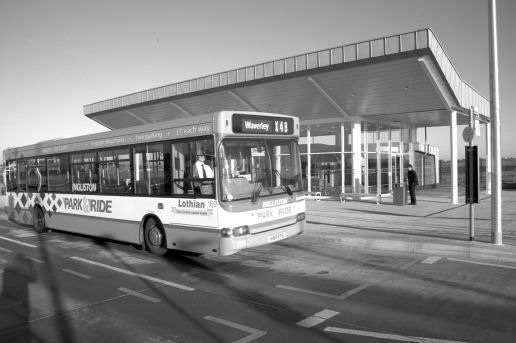
7.30 A key objective of the local plan is to reduce reliance on the private car and maximise accessibility for all, including through the provision of dedicated infrastructure to encourage public transport use. The Council is progressing the West Edinburgh Tram system, as well as providing two new park & ride sites at Ingliston and Hermiston. It has also introduced bus priority measures on the A90. The introduction of quality public transport facilities at accessible locations in Rural West Edinburgh can play an important role in encouraging commuters and visitors to park their cars outside the city and continue their journey by public transport. This should ease traffic congestion and encourage travel by means other than the private car. The local plan, therefore, generally supports new or improved high quality car parking facilities where associated with park & ride facilities at rail stations or with frequent high quality bus services.
7.31 There are currently two rail stations located within the Rural West Edinburgh area, at Dalmeny, and Curriehill. Both of these play an important role in providing public transport links between the local plan area and the city centre, in particular. The car park at Curriehill Station is currently underused, which may in part reflect concerns regarding personal and vehicle security, its peripheral location and lack of connecting bus service. Scotrail is encouraged to introduce security measures such as CCTV in order to promote greater use of this station, particularly by commuters.
Policy TRA7 - Public Transport
Development proposals should be laid out and designed to allow public transport to be as accessible as possible. The Council will support proposals to improve the level and quality of public transport facilities and services throughout the local plan area. It will also support proposals for new or improved high quality car parking facilities associated with rail stations or linked to high quality bus services, provided these are consistent with the Council's Local Transport Strategy and Policy TRA3.
Transport Proposals
7.32 The Edinburgh and the Lothians Structure Plan requires the local plan to safeguard land for a number of strategically significant transport schemes in Rural West Edinburgh. The schemes include major public transport proposals and two park & ride facilities, which are being given priority within the Council's Local Transport Strategy. The schedule at the end of this chapter provides details of all ten local plan transport proposals. Some of these schemes are in the control of the Council, others depend on the Scottish Executive or others for implementation. As some of the proposals are still subject to on-going studies to determine their final route/location, it is not possible to show them all on the Proposals Map. However, when detailed schemes have been agreed, the Council will still safeguard land for these proposals, where necessary, to enable these schemes to be implemented.
7.33 The Council expects that the transport proposals T1-T4 will be implemented within five years of the adoption of the plan. National and strategic planning guidance emphasises the need for the integration of policies for land use and transport and co-ordinated public transport initiatives to reduce car usage. Proposals T1 for a West Edinburgh Tram and T2 for park & ride facilities are part of this framework. The proposed tram route will link the city centre to Newbridge, via Edinburgh Park, the Gyle, Gogarburn and Edinburgh Airport. It is expected that the system will be operational as far as Newbridge by 2009. Further extensions have strategic support, including Livingston and Queensferry via Kirkliston, and will be investigated and safeguarded as appropriate at later phases. The tram scheme will be complemented by a park & ride facility at Ingliston. The tram line is shown on the plan to Newbridge. Lines to Queensferry and Livingston are still being finalised; when the Council has agreed final alignments, they will be safeguarded. Proposal T11 is to safeguard land for a route for a guided busway from the proposed park & ride facility at Ingliston (Proposal T2) to Gogar Roundabout. This could link with the West Edinburgh Busways (WEBS) scheme and allow access from the Airport and Ingliston via Edinburgh Park, the Gyle and the city centre. However, this safeguard is a contingency measure and the section of guided busway would only be developed in the event that proposal T1 for the West Edinburgh Tram was not implemented. Full parliamentary approval for the busway was granted in July 1998 through the 'City of Edinburgh (Guided Busways) Order Confirmation Act 1998'.
7.34 Structure Plan Policy TRAN1 requires the safeguarding of five bus-based park & ride sites in Edinburgh, two of which are in this local plan area. As the identified sites at Ingliston and Hermiston are in the Green Belt, proposals must incorporate extensive landscaping in order to minimise visual intrusion on its character. A site to the east of Eastfield Road and Ingliston has recently received outline planning permission for a park & ride facility. This is shown on the Proposals Map.
7.35 In association with the Hermiston park & ride site, it is proposed to dual the section of the A71 between the Edinburgh City Bypass and Riccarton Mains Road, improve the junction between the A71 and Riccarton Mains Road, and realign the latter (Proposal T3).
7.36 In September 2007, the Scottish Government decided not to proceed with the proposal for a direct rail link to Edinburgh Airport. An alternative solution is now being brought forward making use of existing rail lines linked by the proposed Dalmeny Chord, a new intermodal station at Gogar incorporating a tram interchange to the Airport (Proposals T4 and T5). In addition, the Council supports the principle of a railway station at Newbridge/RathoStation. Two possible station sites are safeguarded for this purpose (Proposal T6).
7.37 Proposals T7 and T8 relate to road construction and improvement schemes in Rural West Edinburgh which are being reviewed by consultants commissioned by the Council in the context of the Local Transport Strategy. The local plan will safeguard land for these proposals and show them on the Proposals Map until such time as they are implemented or a formal decision is taken to abandon them. A revised alignment is under consideration for the Currie bypass, which may omit the Balerno section and terminate at Lanark Road West, east of the junction of Bridge Road, Balerno, as shown on the Proposals Map for the Currie Balerno Local Plan 1983.
7.38 Proposal T9 (A8000 Road Improvement Scheme) is a structure plan scheme but following the Government's 1999 Strategic Roads Review, it is no longer being promoted by the Scottish Executive. Instead, it has been remitted to this Council to consider whether to implement the scheme, in conjunction with neighbouring authorities and other interests. In April 2000, the Council's Transportation Committee agreed to approve an alignment for the new road and to recommend to Planning Committee that land for the scheme be safeguarded in the Rural West Edinburgh Local Plan.
7.39 The scheme approved is for a new off-line, dualled road linking the A90 with the M9. The new road runs through the Green Belt from north of Kirkliston and joins the A90 at a major new interchange, to the east of the Echline roundabout. The scheme also involves widening the A90 to six lanes between the new interchanges and the Forth Road Bridge. The safeguarded road corridor is shown on the Proposals Map.
7.40 The WEPF proposes significant levels of new development in West Edinburgh. A transport appraisal (WETA) has been undertaken to help inform decisions on what transport interventions are required to serve this level of development. Following the completion of WETA, a preferred package of transport interventions has been identified. These are set out in Figure 7.1. Information in the comments column indicates which interventions are identified as local plan proposals. The West Edinburgh Development Partnership will undertake further work to prioritise the identified measures and investigate funding options.
| Transport Interventions | Description | Comments |
|---|---|---|
| Active travel package | High quality pedestrian and cycle routes through the development area and providing wider links. | The main cycle route through the IBG is identified as part of local plan proposal T1. Other proposals will be identified in the WESDF. |
| Bus Priority Measures including on M8 and A89. | Hard shoulder bus lane on M8 and bus priority at junctions on A89 corridor and elsewhere. | Improvements to be delivered within existing highway boundary. |
| IBG Tram Halt | Additional tram stop to serve IBG | Part of local plan Proposal T1 |
| Dualling of Eastfield Road and replacement of Dumbbells junction | Dualled road along whole length from A8 dumbbells junction to roundabout at the airport. Additional carriageway to be provided on land to east of existing road line. Existing dumbbells to be replaced by substantially rebuilt signalised roundabout with two bridges carrying A8 over the roundabout and a 3 lane capacity. Widening on A8 approaches to and possibly through junction to provide bus priority. | Local plan proposal T10 indicative location shown on Proposals Map. |
| Gogar Link Road through International Business Gateway | Largely single carriageway with some widening to allow public transport priority. | Local Plan proposal T11 indicative route shown on Proposals Map. |
| New junction on A8 for Royal Highland Centre | New junction on A8 west of dumbbells to serve RHC development north and, in the future, south of the A8. | Local Plan proposal T12 indicative location shown on Proposals Map. |
| Newbridge junction capacity enhancement | Public transport priority and/or enhanced lane capacity on M9 spur towards A8 and on merge into A8 from M9. Additional public transport priority and/or capacity on A8 approaches to Newbridge. | Local Plan Proposal T13 indicative location shown on Proposals Map. |
| Gogar junction capacity enhancement | Likely to include extra lane on inside of existing roundabout. May also require some widening of approaches. | Local Plan Proposal T14 indicative location shown on Proposals Map. |
| Short M8 link | New dual carriageway road link from M8 to improved dumbbells junction on A8. Will require bridge over railway line and new junction on M8. | This intervention is not necessary to serve the level of development anticipated in West Edinburgh in the interim period. It is therefore not identified as a local plan proposal at this time. However in the longer term, a short M8 link may be required to provide additional road capacity and reduce congestion. The need for this intervention will be kept under review as development in West Edinburgh proceeds. If necessary, a proposal for a short M8 link will be brought forward through future development plans. |
Policy TRA8 - Transport Proposals
Land is safeguarded for the following public transport proposals (T1 - T6) in order to reduce car usage, improve public transport provision and ease traffic congestion:
- T1: West Edinburgh Tram (Edinburgh City Centre - Edinburgh Park - Gogarburn - Edinburgh Airport - Newbridge with extensions to Queensferry and Livingston; (part of the alignments still to be established)
- T2: Park & Ride Facilities at Ingliston and Hermiston;
- T3: A71 (Eastern section) and Riccarton Mains Road junction improvements;
- T4: Gogar Inter-modal Station;
- T5: Dalmeny Chord rail link;
- T6: Newbridge rail station safeguards.
Land is also safeguarded for the following roads proposals:
- T7: Currie Bypass;
- T8: Upgrading of A71 to west of Riccarton Mains road junction (currently under review);
- T9: A8000 road improvement scheme;
- T10: Dualling of Eastfield Road and replacement of dumbbells junction on A8:
- T11: Gogar Link Road;
- T12: Additional road junction on A8;
- T13: Improvements at Newbridge Roundabout;
- T14 Improvements at Gogar Roundabout.
7.41 The Council will minimise the impact of transport schemes on the built and natural environment. It is important that consideration is given to alignment, siting and design in order to reduce the impact of proposals on visual, rural and residential amenity and on areas of nature conservation value. In addition, many of the transport proposals are in the Green Belt. The local plan supports these in principle as justified exceptions to green belt policy. However, it is essential that the impact on green belt objectives is minimised; effective noise mitigation measures should be incorporated, and substantial high quality screening and landscaping will be an essential component of all proposals. To address these issues, an Environmental Statement may be required as part of a planning application or Notice of Intention to Develop.
Policy TRA9 - Transport Proposals
The Council will seek to minimise the impact of transport proposals on the environment. Careful consideration will be given to the proposed alignment, noise mitigation, siting, and design. Adequate levels of high quality screening and landscaping must be provided.
| Proposal Reference | Proposal | Provider | Comments |
|---|---|---|---|
| T1 | West Edinburgh Tram (Edinburgh City Centre-Edinburgh Park-Gogarburn- Edinburgh Airport-Newbridge with extensions to Queensferry and Livingston). | CEC/Private | Corridor safeguard to be established. The tram service from the City to the airport is anticipated to be operational by 2012. The route from the airport to Newbridge continues to be safeguarded. In order to maximise accessibility to and through the IBG, part of the tram route will also form a bus and cycle corridor. |
| T2 | Park & Ride facilities at Ingliston and Hermiston. | CEC/Private | Both sites will be served by public bus services initially. The Ingliston site will also be served by the West Edinburgh Tram. |
| T3 | A71 (eastern section) and Riccarton Mains Road junction improvements. | CEC | These improvement works will be undertaken in association with the Hermiston Park & Ride site. |
| T4 | Gogar Inter-modal Station. | SE/Rail Operators/ Airport Operator | A new rail/tram station is proposed at Gogar which will provide improved public transport accessibility to the airport, RHC and IBG. |
| T5 | Dalmeny Chord rail link. | Network Rail/ Strategic Rail Authority | The proposed chord should allow increased use of the rail network for freight and passenger trains. |
| T6 | Newbridge Rail Station | CEC/Rail Operators/ Strategic Rail Authority | Details of proposal to be finalised. 2 potential station locations are safeguarded. |
| T7 | Currie Bypass | CEC | Scheme subject to Review. |
| T8 | Upgrading of A71 to west of Riccarton Mains Road junction. | CEC | Scheme subject to Review. |
| T9 | A8000 road improvements. | CEC and others. | Alignment approved. Detailed scheme under development. |
| T10 | Dualling of Eastfield Road and replacement of dumbbells junction on A8. | West Edinburgh Development Partnership | Further work to be undertaken on the details and delivery of this proposal. |
| T11 | Gogar Link Road. | West Edinburgh Development Partnership | To be incorporated into proposals for IBG. Further work to be undertaken on the details and delivery of this proposal, including any environmental mitigation, where necessary. |
| T12 | Additional road junction on A8. | West Edinburgh Development Partnership | New road junction to serve RHC development to the north and south of A8 and also housing to east of Ratho Station. |
| T13 | Improvements to Newbridge Roundabout. | West Edinburgh Development Partnership | Improvements to provide public transport priority and/or enhanced lane capacity on M9 and A8 on and approaching Newbridge roundabout. Further work to be undertaken on the details and delivery of this proposal, including any environmental mitigation, where necessary. |
| T14 | Improvements to Gogar Roundabout. | West Edinburgh Development Partnership | Likely to include extra lane on inside of existing roundabout. May also require some widening of approaches. Has implications for land outwith the local plan boundary. Further work to be undertaken on the details and delivery of this proposal. |